Saturday was a relatively normal day in Davis, Calif. Then, shortly after 6:30 p.m., cellphones sprang to life with a shrill scream — a tornado warning.
Eventually, a twister touched down. It was ultimately rated EF0, or the weakest on a zero-to-five scale. The tornado was also preceded by another type of whirlwind.
It was sunny and late in the day in Davis, near Sacramento, as one lone, rotating severe thunderstorm approached from the north. The storm was low-topped — only about four or five miles tall, compared with 10 to 12 miles tall for Great Plains supercells — but it began to rotate.
Around 6:15 p.m., a surge of cool air ahead of it spun up a whimsical little whirl called a “gustnado.” These form on outflow and are typically weak and short-lived, sort of like a dust devil. It was just a prelude of things to come.
At 6:36 p.m., the National Weather Service in Sacramento issued a tornado warning for east central Yolo and northeastern Solano counties in California’s Central Valley, including eastern Davis, western Sacramento and the heavily traveled Interstate 80 corridor. Doppler radar showed a broad but well-defined “couplet” (where red meets green on the radar image below), indicating rotating winds just above the ground.
“We did have that tighter couplet and that mesocyclone being scanned,” said Karleisa Rogacheski, a meteorologist at the National Weather Service in Sacramento.
A mesocyclone is the rotating core of a supercell storm. While the mesocyclone is much larger than a tornado — typically several miles across — and can happen without a tornado developing, it is where tornadoes from supercells usually develop.
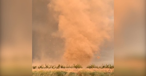
At 6:41 p.m., the NWS office received a report of a tornado from a University of California at Davis atmospheric sciences student. Cellphone video quickly emerged of the funnel touching down at the intersection of Highways 101A and 29. It quickly swirled up lots of dirt and some hay bales.
While no property damage has yet been reported, Davis was lucky. The scene would almost certainly have been different if the storm was a mile or two farther south or west.
“In the video, we did see a wall cloud and a very clear tornado. So we’re classifying it as an EF0 tornado,” said Rogacheski.
Some folks initially presumed the funnel might be a landspout — a ground-based whirl whose circulation became entrained and stretched into the clouds. But signs point to the vortex being a bona fide, albeit weak, tornado.
Part of what may have prompted the landspout hypothesis was the lack of a condensation funnel. In other words, the tornado did not look like the typical Great Plains monsters, with large lurking funnels dangling from the cloud to the ground. Landspouts tend to favor storms that are not rotating supercells, although they can form in them at times.
In this case, the lack of a fully condensed funnel was probably due to California’s characteristically dry air and the resultant high bases of the clouds. Indeed, radar analysis revealed the tornado to be collocated with the strongest cloud-base rotation, in a region of the storm that harbored supercell tornado potential.
Additionally, strong northerly winds can be seen jostling tree tops and heard in the video, indicating a surge of cool air — the “rear flank downdraft” — descending on the backside of the storm and tightening rotation.
It’s also possible that the twister may have started as a purely supercell tornado and ended up as something of a hybrid vortex.
Despite the lack of widespread severe weather risk, the supercell formed beneath a chunk of very chilly air in the upper atmosphere.
The upper low “was unseasonably cool for this time of year, and when that happens there’s a good chance of thunderstorms,” explained Rogacheski.
Hail from the storm also coated the ground in spots, while the departing thunderstorm’s sunlit anvil made a beautiful backdrop around sunset.
The twister came as a surprise, although they do happen annually in California, and the Central Valley is a preferred region for them to touch down. They tend to favor early spring over fall, but any time huge low-pressure systems are arriving off the Pacific Ocean, the ingredients may try to come together.
The Golden State averages 11 tornadoes each year, many of which are short-lived and not photographed. This one comes after a beautiful low-precipitation supercell that spun over Northern California’s Shasta Valley earlier this year during a busy spring that also included a few other quick tornadoes in the region.
Ian Livingston contributed to this report.
by Matthew Cappucci (2019, Sept 30) The Washington Post