Gisela Bosco was making coffee Monday morning when something bashed into her Loxahatchee home so hard she thought her roof was being wrenched away in the pre-dawn darkness.
A tornado warning had lit up phones and television scrolls about 5 minutes before. She took a split-second inventory; one child was in the bathroom, another was asleep.
“I just started screaming. I was yelling for them to get in the closet,” said Bosco, whose home near Seminole Pratt Whitney Road was in the path of a tornado that spun up Monday. “There was a moment when there was a freak out. It was very, very scary.”
Before many alarm clocks rang awake Monday, National Weather Service forecasters were tracking a severe thunderstorm slingshot into western Palm Beach County by a low-pressure system boiling in the Gulf of Mexico.
The tornado, judged to be an EF-0 with up to 80 mph winds, touched down at 5:34 a.m. near 71st Place North and Apache Blvd. It ripped a 1.5 mile-path northwest across Seminole Pratt Whitney Road before lifting four minutes later near Valencia Blvd. and Banyan Blvd.
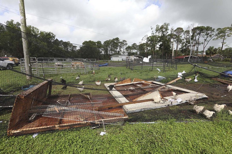
In the short rampage, the twister tossed trampolines, toppled a bunny cage and a chicken shed, shredded pool screens, knocked on doors loud enough to set off a burglar alarm, obliterated at least one shed and uprooted a tree in the paddock of an 18-year-old horse named Flash.
Mike Jordan, Flash’s keeper, said he was watching the news when the worst of the storm hit. He heard the tornado warning.
“About two minutes after that, there it was,” he said.
The Jordans, their sons and neighbors walked around their soggy yard Monday morning assessing the damage and beginning repairs. One neighbor sat perched on top of their stable helping secure a tarp to protect Flash from the rain.
Around the corner on Apache Boulevard, Mary Burgio already had a worker from Loxahatchee-based Glass Guys repairing eight panes of glass on her home.
Siding was torn from her shed and a cover for her water system was tossed down the street. “But surprisingly, my son’s wheelbarrow is fine,” she said. “A $20 wheelbarrow and it’s just sitting there.”
The soupy swirl of low pressure hugging Florida’s west coast was given a 30 percent chance of developing into a tropical or subtropical system over the next five days as it heads north into the Panhandle.
Regardless of whether it gets a name — Alberto is the first name on the tropical cyclone list this year — National Hurricane Center forecasters said the slow-moving area of showers and thunderstorms promises rain in South Florida for several days.
As of early Monday afternoon, 24-hour rain totals were as high as 5 inches in areas of coastal and Central Palm Beach County. Another 5 inches is possible through Saturday morning.
“They’ll be some peaks of sun here and there,” said Chris Fisher, a meteorologist with the NWS in Miami. “It’s hard to pin down a rain estimate, but, areawide, it could be another 3-5 inches through the end of the week.”
Heavy rainfall of more than 5 inches in 24-hours north of Lake Okeechobee forced South Florida Water Management District officials to close a navigation lock near Taylor Creek to boat traffic so it could remain open for flood control. District meteorologists are forecasting up to 6 inches of additional rain through Friday.
Robert Molleda, the warning coordination meteorologist for the NWS office in Miami, was in West Palm Beach on Monday for the Governor’s Hurricane Conference. The conference is being held at the Palm Beach County Convention Center through Friday.
He dropped materials off at the conference and headed west to survey the tornado damage. Clues he looks for to determine if a tornado actually touched down is a narrow, straight path. The path Monday was about 150-feet wide.
“Obviously, the thing you want to see most is that there were no injuries, and no major structural damage,” Molleda said. “This was damage pretty consistent with an EF-0.”
It’s not unusual for tornadoes to form inside the roiling outer thunderstorms of hybrid-like systems such as the one in the Gulf, Molleda said.
In Brevard County, a tornado that started as a waterspout in the Banana River whacked a mobile home park on Merritt Island on Monday. The weather service in Melbourne confirmed the damage was consistent with a low-end tornado.
Broward County sheriff’s deputy Erica Chace’s home was near the path of Palm Beach County’s tornado. She stood in the backyard of her home on 74th Street North surveying extensive damage to her roof, including large patches of missing shingles. The fascia at the front of her house was pulled away, forming a “U” shape away from the rest of the roof.
Missing from Chace’s yard: her lawn furniture and a yellow recycling bin. “I think some of my lawn furniture may be in the pond,” she said. “I found some cushions kind of floating in there.”
Across the street, Lazaro Santos was picking up pieces of his farm yard. He also was missing something, albeit much larger: a 700-pound shed that sheltered his 9-year-old mare.
“I don’t know where it is,” he said, gesturing to the sky. “It’s just gone.”
Santos was asleep when the storm began moving through. He woke up to his burglar alarm going off, and walked out to see his back doors trying to open inward as his front doors were sucked open.
“All of the windows started rattling,” he said. “I brought my kids in my closet and within seconds it was over.”
by Kimberly Miller and Kristina Webb (2018, May 14) Palm Beach Post