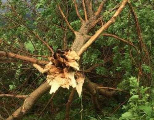
With hundreds of tornado reports only four months in, 2017 could rival both 2008 and 2011 as one of the most active tornado seasons in recent history.
However, as the United States’ severe weather season shifts into its climatological peak, experts agree that it might be too early to determine.
“Certainly, we’re off to a really fast start, but we haven’t gotten to the big part of the season yet,” said Harold Brooks, senior research scientist at the National Oceanic and Atmospheric Administration’s (NOAA) Severe Storms Laboratory.
“Half of tornadoes typically happen in May and June, so if those months end up being below normal, the year won’t be much above normal at all,” he said.
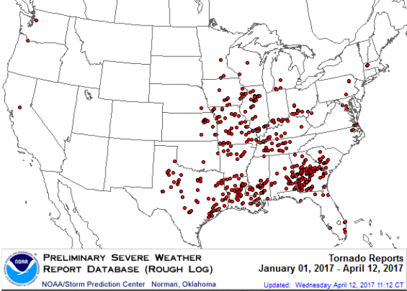
Since January, the National Weather Service’s (NWS) Storm Prediction Center data shows more than 500 possible reports of tornadoes in the U.S.
Both 2008 and 2011 had record tornado numbers.
2008’s more than 2,100 possible tornadoes is considered well above the 10-year average, according to the Storm Prediction Center.
Of those, approximately 36 were rated between EF3 and EF5 (wind gusts ranging from 136 mph to more than 200 mph) on the Enhanced Fujita Scale.
In 2011, the National Centers for Environmental Information’s (NCEI) State of the Climate Report confirmed more than 1,600 tornadoes with a death toll of 551.
While 2017 has been active thus far, there is not necessarily a correlation between previous tornado reports this year and those that haven’t yet occurred, said Brooks.
“The beginning of 2012 to March 2 was a big year, then it just stopped having tornadoes,” Brooks said.
The NCEI reported more than 870 confirmed tornadoes that year.
“We’ve had other years such as 2003, which began as one of the smallest years on record through April 30, but by May 10, it was well above average,” Brooks said.
Experts say one of the reasons behind this active year could be the record warmth in the Gulf of Mexico, particularly near the western Gulf and the Loop Current, which is a flow of warm water that travels through the Gulf and past the Florida Keys.
“This leads to a more humid air mass over the Gulf, which can then be transported northward by wind into the U.S.,” said Dr. Victor Gensini, associate professor of meteorology at the College of DuPage in Illinois.
A relatively warm winter with fewer cold fronts across the southern U.S. might also be the cause, according to Dr. John Allen, assistant professor of meteorology at Central Michigan University.
“[This allows] warm, moist conditions to build, so that any systems that do come in have access to greater instability,” Allen said.
“The near-surface air over the inter-mountain region has also not cooled as significantly, which has led to enhanced lapse rates of temperature with height, another important ingredient to instability,” he said.
Low angular momentum has also been observed for a large majority of late last winter and early spring, said Gensini.
Research has shown that low angular momentum can play a role in tornado activity, he said.
“Think of angular momentum as a measure of how meridional (or roller-coaster-like) the jet stream is,” Gensini said.
A weather pattern with low angular momentum, which is associated with large dips and bulges in the jet stream, is more conducive to severe weather outbreaks, Gensini said.
The jet stream is a fast river of air around the level that jets typically fly.
La Niña may have also played a role in tornado conditions.
“In terms of the seasonal factors, the weak La Niña appears to have had a lasting influence on the midwinter, with higher winter and early spring tornado frequency typically associated with
La Niña and the resulting wavier jet stream,” said Allen.
Experts generally agree that the rest of April does not appear as active as the earlier part of 2017.
“The first half of April will probably go into the books as about normal or slightly below normal,” said AccuWeather Enterprise Solution Senior Vice President Mike Smith.
“There are some indications that May will be active, but I think that this storm season will end up about average,” he said.
According to Allen, the year has already fallen off pace with the more than 500 preliminary tornado reports through mid-April, compared to 621 reported tornadoes in 2008.
“Unless we see some enhanced activity by the end of April, we will likely be ending up a little less of an outlier behind 2008 and 2011,” said Allen.
“Nonetheless, with a start like this, even following the average rate for the rest of the year would put us in the top three,” Allen said.
by Ashley Williams
April 17, 2017