Strong winds toppled trees and power lines and even ripped off the roof of a mobile home in northwest Iowa Tuesday, while at least 10 other tornadoes threatened the tri-state area.
There were no reports of injuries from the reported tornadoes that touched down throughout eastern South Dakota, Minnesota and Iowa, the National Weather Service said.
Four tornadoes touched down in northern South Dakota on Tuesday afternoon, while northwestern Iowa and southwestern Minnesota both had touchdowns reported.
Two tornadoes touched down in Day County, but the National Weather Service hasn’t received any reports of damage. The first tornado touched down about six miles west of Webster at 2:37 p.m. The second tornado touched down around 3:30 p.m. near Bitter Lake, about a mile south of Waubay, the National Weather Service said.
Tornado locations:
Northwest Pipestone, Minn.
Lake Park, Dickinson, Iowa
Bristol, SD
Waubay, SD
Blue Earth, Minn.
Waterville, Minn.
Corona, SD
Wilmot, SD
Le Sueur, Minn.
Beardsley, Minn.
Barry, Minn.
Bremer, Iowa
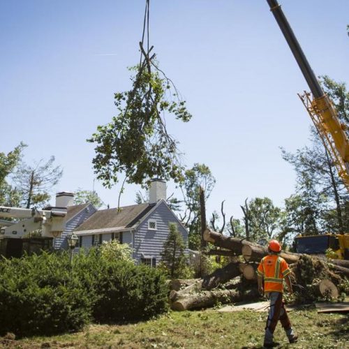
The NWS confirmed that a tornado touched down one mile northwest of Pipestone, Minn., and another was on the ground seven miles south of Lake Park, Iowa. NWS has not yet received reports of damage caused by the tornadoes, but meteorologist Brad Adams said that they have heard initial reports of substantial damage in the Spirit Lake, Iowa, area caused by strong winds.
Just before 3 p.m. in Spirit Lake, a roof was blown off of a mobile home and numerous power lines were reported down, according to the NWS. There was also widespread tree damage and flash flooding. About eight miles south, the town of Milford, Iowa, also saw trees and power lines down from wind damage. The NWS reported between 60 and 70 mph gusts.
ARGUS LEADER
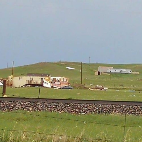
EF-2 tornado damages homes near Hermosa
Both the tornado warnings and thunderstorm warnings for the area have since expired.
Update 3:50 p.m.: The tornado warnings in northeast South Dakota have expired.
Update 3:45 p.m.: A tornado reportedly touched down near Blue Earth, Minn., according to the NWS. Multiple law enforcement officers reported they saw a tornado touch down briefly then go back up around 3:30 p.m.
Update 3:30 p.m.: A second tornado was reported near Bitter Lake, 12 miles east of Webster, moving northeast at 25 mph.
Update 3 p.m.: A tornado was reported about six miles west of Webster in northeastern South Dakota, according to the NWS.
A tornado warning was in effect for Day County, Eden, Fort Sisseton Station and Roy Lake State Park until 3:45 p.m.
A tornado watch is in effect for Grant, Marshall and Roberts counties until 10 p.m. Tuesday.
Update 2:40 p.m.: A tornado watch has been issued for southwestern Minnesota, from west of Marshall to just east of Saint Paul and just north of Saint Cloud until 10 p.m.
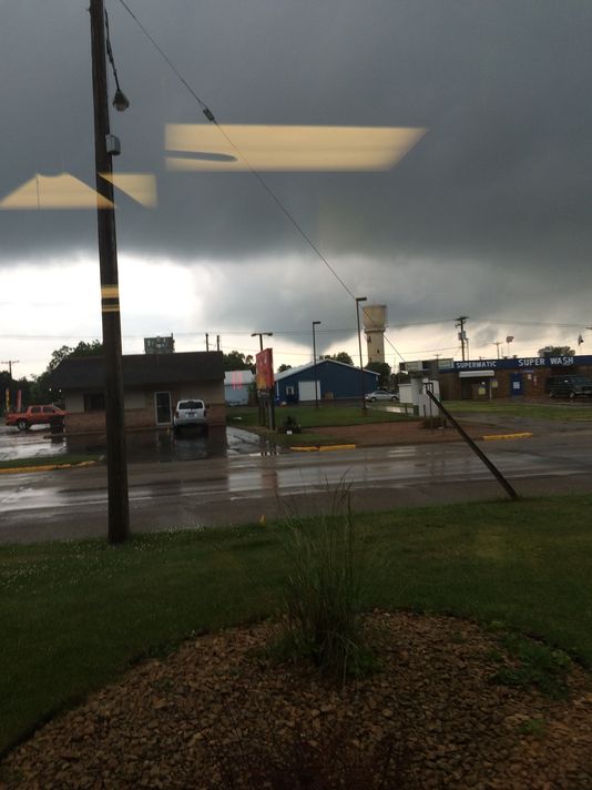
Earlier, a “damaging tornado” was seen on the ground near Pipestone, Minn., shortly before 2 p.m. Tuesday, moving north at 20 mph. There was no immediate report of damage or injuries.
A few counties along the Minnesota-Iowa borders are under a tornado warning until about 3 p.m.: central Dickinson County in Iowa and southern Jackson County in Minnesota. A storm capable of producing a tornado was seen around 2:30 p.m. 8 miles west of Spirit Lake moving northeast at 35 mph, according to the NWS.
Severe weather could strike the Sioux Falls area on Tuesday afternoon, with strong winds, hail and tornadoes within the range of possibility.
The storms are expected to start around 1 p.m. and last until about 8 p.m., the National Weather Service office in Sioux Falls said.
“The main threat is locally heavy rain,” meteorologist Mike Gillispie said of the Sioux Falls area.
A severe thunderstorm watch has been issued until 9 p.m. for the following South Dakota counties: Brookings, Moody and Union.
The Storm Prediction Center says that eastern South Dakota, including Sioux Falls, Yankton, Brookings, Watertown and Sisseton, has a slight chance of severe weather developing, while most of central and western South Dakota only has a marginal chance. Southern Minnesota and northwest Iowa have an enhanced risk of severe weather.
SPC maps also show a higher than usual chance for tornadoes in the area. Parts of eastern South Dakota have a 5 percent chance of a tornado within 25 miles of any given point, while others, including Sioux Falls, have a 2 percent chance.
Chance of a tornado within 25 miles of a point on Tuesday.
Chance of a tornado within 25 miles of a point on Tuesday. (Photo: Storm Prediction Center)
Hail is possible with these storms, primarily in Iowa and southern Minnesota, Gillispie said. The storms are expected to worsen as they move east, meaning southern Minnesota and northern Iowa have a moderate risk of tornadoes while South Dakota only has a slight risk.
“Most of the activity is going to be east and south of us,” Gillispie said. “It looks like we’re going to be on the back end of things.”
A tornado hit north of Hermosa in western South Dakota on Monday afternoon, damaging some homes. The National Weather Service will be assessing the damage on Tuesday to determine an EF value for the tornado.
63 CONNECTTWEETLINKEDIN 1 COMMENTEMAILMORE
TOP VIDEOS
Katie Nelson and Danielle B Ferguson, dbferguson@argusleader.com
Photo: Mary Risacher