Highlights:
The savage storm was born in a monster low-pressure system that formed 4,000 miles away
Forecasters at Storm Prediction Center in Norman, Okla. knew deadly storms were likely May 22, but where?
This story was originally published Dec. 11, 2011
On a steamy Sunday afternoon in May, Andy Foster grew more and more uneasy.
All day he’d been tracking air pressure, wind patterns and moisture levels from his home halfway between Springfield and Joplin. Now, sensing menace in the west, the National Weather Service forecaster decided to head into work early.
Violent weather in spring is as common as dandelions on Foster’s turf in southwestern Missouri. Yet in nearly 20 years, only a handful of days gripped his gut. May 22 was one of them.
The senior forecaster strode out the door around 3 p.m., squinting in the sunshine, thinking about the work ahead for him and his colleagues at the weather service office in Springfield.
You might want to pray for us, he told Heidi, his wife. Things don’t feel right.
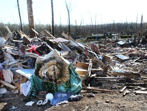
In the next 2 1/2 hours, the weather would deteriorate from bad to catastrophic. Huge thunderstorms would fire up in eastern Kansas and come crashing together, ultimately unleashing an EF5 tornado on top of Joplin.
By nightfall, more than a third of the city would be obliterated, 9,500 people displaced, more than 1,000 injured and 161 dead or dying.
Tornadoes are chaotic and mysterious, terrifying in their intensity but so rare and short-lived that they defy close study. Today, more than 100 years after the first tornado researcher set out from Kansas City, we still do not know exactly how a tornado forms or what its internal structure looks like.
So it is astonishing to learn that scientists can trace the origins of the Joplin tornado back to a weather system that formed two weeks earlier and 4,000 miles away.
Here is the story of that storm system.
From the beginning, slowness defined it. Tedious, plodding, grinding, unrelenting slowness. Down the Pacific Coast, across the California highlands, over the Rocky Mountains. And when the storm system took an unexpected turn as it spread into the central Plains, the table was set for violent weather.
Somewhere.
Science and technology help explain what happened as the system lumbered along, loosing increasingly harsh weather on whoever happened to be caught underneath it.
But this is also the story of why we don’t know more.
Overloads of information hide meaningful patterns. Tiny, last-second interactions scramble calculations. Radar can’t see a tornado moving on the ground.
So late Sunday afternoon, when Andy Foster saw a bright pink stain explode on a high-altitude radar scan, he knew this was no isolated twister taking out a chicken coop. Pieces of houses, churches and barns had been blasted 10,000 feet into the sky over Joplin.
“That’s when our hearts sank.’’
Two weeks earlier, Mother’s Day, May 8, could not have been more picturesque in Joplin: 80 degrees at noon with a light breeze and lower-than-average humidity. Keith Stammer spent the day with his wife, children and grandchildren at a backyard cookout. The emergency management director for Jasper County, where Joplin is located, was grateful for the calm.
Killer tornadoes had hit nearby towns on and before Mother’s Day in recent years, but this season was wrapping up without incident.
OK, maybe we’ve made it, he thought.
Across town, Malisa Crossley, a Walmart customer service manager popular with colleagues and customers alike, spent the day with her 9-year-old son, Chaz; her roommate, Angela Baumann; and Baumann’s Chihuahua, Frappé. They rented a two-bedroom, 1940s-era bungalow in a neighborhood full of modest, older homes next to St. John’s Regional Medical Center in southwest Joplin.
Crossley called her mother in Texas. She was a good daughter that way, never forgetting birthdays or special occasions.
Some 4,000 miles away in the Gulf of Alaska, Toby Burke, husband and father of nine, also had family on his mind.
The bird expert for the U.S. Fish and Wildlife Service was one of 20-some people on board the M/V Tiglax research ship, a 120-foot vessel built for withstanding big weather that had cruised the gulf’s waters for two months. Burke was aboard to observe seabirds and their habitats during the spring migration, knowing full well that identification skills were not the only requirement for this type of work.
“If an observer is brutally honest,” he once wrote of his job, “equally important is their ability to endure long hours on a ceaselessly rolling and pitching deck in less than ideal weather, all too often with nary a bird in sight.”
Now the ship was one day away from its home port in Homer, Alaska. Burke was on deck by 7:30 a.m.
The temperature lingered at an unusually chilly 40 degrees all day. By the time the Tiglax sailed out of the calm waters of Prince William Sound and back into the gulf, the sky was choked with clouds.
A light, steady rain began to fall.
The moist air rising, cooling and condensing that drab day was the first manifestation of the Joplin tornado’s meteorological footprint. For the next nine days, the low-pressure system that chilled the Gulf of Alaska chugged slowly southward, then hovered off the coast of northern California, waiting for the boost of energy it needed to make landfall.
The reason we have weather — the reason skies aren’t clear every day — is the planet’s unrelenting drive to balance temperature and air pressure. It’s an impossible equilibrium to achieve.
Because the Earth is round, the sun’s heat is distributed unevenly — warm air at the equator and cold air at the poles. And because cold air pushes down on the Earth harder than lighter, rising warm air, air pressure is higher at the poles and lower at the equator.
Trying to even things out, masses of warm air and low pressure from the equator and cold air and high pressure from the poles gradually and constantly move toward each other. They tend to meet in the middle latitudes, where most storms occur. They bump and mix it up in the jet stream, a river of air four to eight miles above the ground that circles the globe.
When the jet stream moves in a fairly straight path from west to east, high-pressure systems rule and skies are blue. When it begins to meander and form deep dips — called troughs — rising warmer air rushes in, creating huge areas of low pressure. Pushed by the jet stream, those low-pressure systems cause bad weather out in front of them.
The central Plains are a breeding ground for severe storms, getting more tornadoes than anywhere in the world. Here, cold Arctic air from Canada, hot dry air from the desert Southwest and moist air from the Gulf of Mexico collide, with an assist from the Rocky Mountains.
The mountains act as a giant skateboard ramp for air masses moving east, shooting them up and over each other, a turbulent meteorological trick that encourages violent weather. That’s why Tornado Alley — the rugged flatlands of Texas, Oklahoma, Kansas and Nebraska — spawns the biggest, baddest tornadoes.
On May 17, five days before the Joplin tornado, the plodding system from Alaska got the shove it needed to make its way east.
A second, faster-moving low-pressure system, also born on Mother’s Day, had steamed east from the Sea of Okhotsk off the coast of Siberia. Pieces of those parent systems created a new one that pushed toward the Rockies.
The next day the system, stretching from California to Colorado, began to turn slightly to the northeast. The meandering northward arc of the system opened the floodgates for moist air from the Gulf of Mexico to pour northward unimpeded for the next five days, setting the stage for severe weather across the Plains from Texas to Canada.
Gulf moisture, jet fuel for violent weather, helped ignite the first severe storm on the system’s leading edge.
It came in the form of ice.
The snowplows were tucked away for the season when a freak hailstorm hit Thornton, Colo., a suburb of 120,000 just north of Denver. At 2 p.m., the streets filled with pea-size hail, a 6-inch blanket at its deepest.
David Nighswonger, the city’s public works director, ordered his crews to pull out the plows.
By the time workers had readied them, the warmth of the streets had started melting the hail. Car tires carved ruts in the slushy ice piles. The plows pushed the rest out of the way.
That afternoon, 190 miles to the south near LaJunta, Colo., private meteorologist Jon Davies was chasing a different storm spawned by the same system for the Weather Channel.
Davies, of Trimble, Mo., near Kansas City, and his wife, Shawna, were filming “gustnadoes” — dusty spin-ups of wind on the leading edge of thunderstorms, weaker than most tornadoes. From their red Subaru Outback, marked by a cellphone antenna and a satellite receiver on the roof, the couple streamed the footage live online.
The storm system that caused the gustnadoes and the unseasonable hail ambled onto the Plains; southerly winds picked up.
On the ground in Kansas, Oklahoma and Missouri, the air started getting soupy.
The earliest tornado researcher, Army Sgt. John Park Finley, began collecting data on tornadoes for the U.S. Signal Corps in 1884, working from a base in Kansas City.
Finley set up a network of more than 2,000 weather reporters before the project was discontinued in 1887. The government, fearful of panicking the populace, banned the word “tornado” from use in forecasts.
More than half a century later, when the government decided to get back in the business of trying to protect citizens from tornadoes, Kansas City again played a key role.
The Weather Bureau relocated its two-year-old Severe Weather Unit from Washington, D.C., to Kansas City in 1954. For 43 years, the government’s top tornado experts worked out of the old Federal Building on Walnut Street and later the current one on 12th Street.
On May 19, three days before the tornado, huge thunderstorms pounded the Plains. Golfball- to baseball-size hail pelted towns and farmland from north-central Texas to central Nebraska.
Safely tucked inside the dispatch center of the law enforcement building in Beloit, Kan., some 400 miles east of Thornton, Colo., Scott Davies could see the view captured by security cameras outside.
It was late afternoon but dark as night.
Davies, the county’s emergency management director, watched what he thought was a typical Kansas thunderstorm unfold — hail, lightning, heavy rain. He appreciated the flashes of lightning, which would make rain-wrapped tornadoes easier to see in the darkened skies.
As the storm moved in from the west, weather spotters and law enforcement officials reported flooded county roads and possible tornado touchdowns in rural areas.
“We did have one farmer lost one or two grain bins,” he said. “It got hairy there for a while.”
As the storm twisted overhead, Mitchell County Sheriff Doug Daugherty’s patrol car moved up and down the streets of Cawker City, 20 miles west of Beloit, home of “The World’s Largest Ball of Twine,” an outdoor tourist attraction.
The town lost electricity, knocking out the warning siren, so Daugherty was sounding his patrol car siren to warn people that tornadoes might be coming. Despite high wind, walls of rains and ferocious lightning, no twisters touched down.
The sheriff was unharmed.
So was the ball of twine.
Every day at 6 a.m. and 6 p.m. Central Standard Time, 800 weather balloons are launched from weather stations in more than 60 countries, including Russia, Pakistan and South Korea, to determine weather patterns for the planet.
Each balloon carries a white box the size of a Chinese takeout container outfitted with sensors that measure pressure, temperature, and humidity as its position is transmitted by GPS. Wind speed and direction are calculated from changes in location over time.
The balloons, 6 feet in diameter and filled with hydrogen or helium, rise about 1,000 feet per minute. A battery-powered transmitter sends measurements continually.
As a balloon rises up to 20 miles high, it expands to 20 or 25 feet and bursts, at which point a small orange parachute slows the equipment’s descent back to Earth.
The balloon launches have been going on since the 1950s. The numerical data are registered on computers at local stations, collected in Washington, D.C., and made public instantly. Universities and private weather organizations turn the raw numbers into maps like the ones seen on TV weather broadcasts.
The data gives forecasters clues about where thunderstorms are likely to form, which is key to predicting tornadoes.
A thunderstorm forms in unstable conditions — when warm, moist air collects near the ground beneath much colder air above. If forced upward by turbulence or other forces, the warmer moist air rises quickly, like a hot-air balloon, to an altitude where the water vapor condenses into tiny droplets and a cloud becomes visible. When the droplets get big enough, rain falls.
A large storm cloud can be twice as tall as Mount Everest — more than 10 miles high and 10 miles wide.
When a cloud shoots up that high, powerful currents of air rush in and force raindrops up to altitudes where they freeze and then fall. Hail gets tossed up and down repeatedly, like a beach ball at a concert, growing larger and larger before gravity pulls it to Earth.
A thunderstorm is most likely to turn severe when unstable air combines with wind shear — scientists’ term for changes in wind direction and/or speed at different heights. Strong wind near the ground begins rolling over lighter wind, like a palm rolling over a drinking straw, creating a horizontal tube of rolling air.
The upward rushing winds tilt the horizontal tube upright a mile or more above the ground, setting off a rotating column of air called a mesocyclone inside the storm cloud.
Then you have a supercell.
A tornado’s womb.
Scientists don’t know why some supercells produce a tornado. When one does, they theorize it looks like this:
The spinning core, or mesocyclone, begins to stretch upward within the storm cloud and down toward the ground. As the tube gets skinnier, it turns faster, like a figure skater who enters a spin with arms extended and then pulls them in tight.
What happens next is a mystery.
The latest research suggests that the elusive trigger lies in small-scale, last-minute interactions on the ground along the seams between upward rocketing and downward plunging air.
Those yet-to-be-defined interactions may determine whether a supercell will produce no tornado, a weak twister or a mile-wide wall of doom.
Frustrating to weather watchers, Doppler technology can detect only the parent mesocyclone high above the ground; the tornado itself is invisible to radar.
That’s because radar can’t “see” close to the ground. Radar beams have to be aimed up at an angle of .5 degrees or more to clear buildings and trees. And because the Earth is curved and the radar beam travels in a straight line, the farther the beam travels, the higher up in the sky it is “looking.”
Only human eyes can see a tornado on the ground; trained spotters remain a crucial part of the government’s warning program.
An EF5 tornado is the most powerful storm on Earth, with winds more than 200 miles per hour, compared to 155 for a Category 5 hurricane.
It is also incredibly rare.
Only one percent of all thunderstorm clouds will produce a tornado.
Only one-tenth of 1 percent of all tornadoes will become an EF5.
By Friday, May 20, conditions looked increasingly grim for Sunday.
The sluggish low-pressure system crawled east and northeast, rather than dropping to the southeast and clearing out the moisture-laden air, as usually happens.
The southerly winds continued unabated, pushing more moist air into southeast Kansas and southwest Missouri, where it began to pool like an invisible lake.
Tornado knowledge and forecasting took a giant leap forward in the 1970s, when University of Chicago meteorologist Tetsuya “Ted” Fujita introduced the Fujita scale.
Unlike hurricane category ratings, the EF, or Enhanced Fujita, rating is not based on measurements of size or intensity, because a strong tornado can destroy any measuring device in its path. The EF scale estimates wind speeds after the fact based on damage.
For a tornado to “earn” an EF3 or higher, it has to hit something that was well-built.
For example, if the EF5 tornado that leveled Greensburg, Kan., in 2007 had touched down in a field five miles away with no structures to destroy, it may have been rated only an EF2.
Using Fujita’s scale, meteorologist Thomas Grazulis spent a decade documenting every significant tornado on record going back to the 1600s. The Nuclear Regulatory Commission paid for the study; it wanted to know how strong a nuclear reactor needed to be built to withstand tornadoes. Grazulis had made tornado research his life’s work after an EF4 twister killed 94 souls in his hometown of Worcester, Mass., in 1953 when he was 8 years old.
His 1,000-page tome was and is a gold mine of data for researchers to feed into computers in an ongoing effort to discern patterns that can help prediction.
Doppler radar revolutionized forecasting by giving meteorologists a peek inside storm clouds. They could issue warnings earlier than ever, giving the public more time to take shelter.
The latest-generation Doppler radar is a key tool used by the national Storm Prediction Center in Norman, Okla., which replaced the Kansas City unit in 1997. There, inside a red brick and blue glass building at the University of Oklahoma, meteorologists work 24 hours a day to identify what parts of the country are at risk for bad weather for the coming 10 days.
Forecasters stare at razzle-dazzle computer models and draw old-fashioned weather maps on paper with colored markers. The quiet is punctuated by computer-generated “ding!” sounds when a severe weather watch is issued and less frequent “ka-ching!” cash-register sounds when a sighting or damage report comes in (because a watch was “on the money”).
Tornado watches and warnings were something Joan Phillips had to get used to when she moved to Joplin five years ago. The president of the high school’s band booster club is an East Coast native who heard her first welcome to Tornado Alley on a sunny day while standing in line at the Lowe’s store.
Good Lord, what is that, she asked the clerk.
Oh, they’re testing the tornado siren.
On Saturday, May 21, gulf moisture continued to stream northward, reloading the gun for atmospheric violence.
All afternoon, severe thunderstorms roared across the country’s midsection.
The National Weather Service issued 43 tornado warnings in seven states from Texas to Minnesota, including Oklahoma, Kansas and Missouri.
After dark, low-level winds from the south speeded up, turned counterclockwise and began blowing from the most tornado-friendly compass direction: SE.
At 9:15 p.m., an EF3 tornado tore through Reading, Kan., a town of 250 people and about 100 homes, 150 miles northwest of Joplin.
The tornado chewed up trees, houses and just about every business in town except the beauty parlor. Most residents didn’t have a basement, but many had keys to the United Methodist Church, which did. Thirty-eight people safely rode out the storm under the church.
Don Chesmore wasn’t so lucky.
Fifty-three years old, a husband, father, grandfather, avid outdoorsman, Chesmore worked part time as a maintenance man at a senior center in nearby Osage City. He and Lavonda, his wife, were in their mobile home when the tornado flipped it over.
Chesmore died later at a hospital in nearby Emporia.
The storm system had just claimed its first victim.
Alarmingly, conditions for Sunday looked even worse.
Tornadoes seemed likeliest from Minnesota to Missouri and eastern Oklahoma.
Sunday, May 22
6:30 a.m.
The morning in Joplin began as every other morning for Keith Stammer, the county emergency management director. He fired up his laptop to check the National Weather Service’s hazardous weather outlook for the day: possible thunderstorms. Large hail looked like the day’s biggest threat.
Looks like it might be interesting weather, Stammer told Kathy, his wife. I might have to work tonight.
After teaching his adult Sunday school class and attending services, Stammer and his wife planned to spend the day at home. Their grown daughter drove to Oswego, Kan., about 40 miles away, to visit her grandparents.
By early afternoon Stammer would be nestled in his favorite chair watching the Kansas City Royals-St. Louis Cardinals game on TV and following bad weather moving toward Joplin on his iPad.
Malisa Crossley decided to call in sick to her job at Walmart. She had a cold and would spend the rest of the day at home, relaxing.
Diagnosed with diabetes at age 5, Crossley was not in good health. Her feet hurt all the time. She sometimes slipped into scary, comatose-like stupors. Lately she’d noticed that her vision was blurry when she was driving. Her mother in Texas had been happy to hear that her daughter had an appointment with a doctor the next day.
She felt like a 36-year-old in a 100-year-old body, Crossley often told her mother, who worried about her daughter living so far from her.
11:17 a.m.
The national Storm Prediction Center upgraded the risk of tornadoes for southeast Kansas and southwest Missouri.
About an hour later, the weather service in Springfield launched an extra weather balloon, trying to get a clearer picture of shifting conditions.
The results scrambled earlier predictions.
The wind shear, questionable at daybreak, now looked ominous.
A low-lying wind from the south, often associated with tornadoes, was blowing hard.
The Convective Available Potential Energy (CAPE) calculation of atmospheric instability had gone from attention-grabbing to off-the-charts.
Worst of all, air masses at ground level were moving toward each other in a foreboding pattern forecasters call a triple point: A cold front (the leading edge of a mass of cold air), a warm front (the leading edge of a mass of warm air) and a dry line (the boundary between dry desert air and moist gulf air) were setting up like a “Y.”
The area in front of a triple point is prime location for violent storms. Southeast Kansas and southwest Missouri were in the crosshairs.
Finally, a layer of warm air up high that acts like a cap, preventing storm clouds from shooting up and becoming severe, was eroding.
2 p.m.
In Parsons, Kan., 50 miles northwest of Joplin, a dark gray supercell mushroomed up into the cornflower sky and began grinding eastward. It was the first of five that would ignite over the next 3 1/2 hours in Kansas and Oklahoma and ultimately crash together.
Often, when supercells collide, they sap energy from each other, short-circuiting tornado formation.
Tragically, the opposite would occur in Joplin. The violent cells would merge, creating a single beast of a storm at the worst possible place, the edge of a city.
3 p.m.
Graduation for Joplin High School’s Class of 2011 started with a regal trumpet fanfare. Band director Rick Castor struck up “Pomp and Circumstance” as 453 seniors in maroon caps and gowns — the school’s second-largest graduating class in 15 years — marched into the Leggett Platt Athletic Center at Missouri Southern State University on Joplin’s northeast side. The seniors filled the rows of folding chairs.
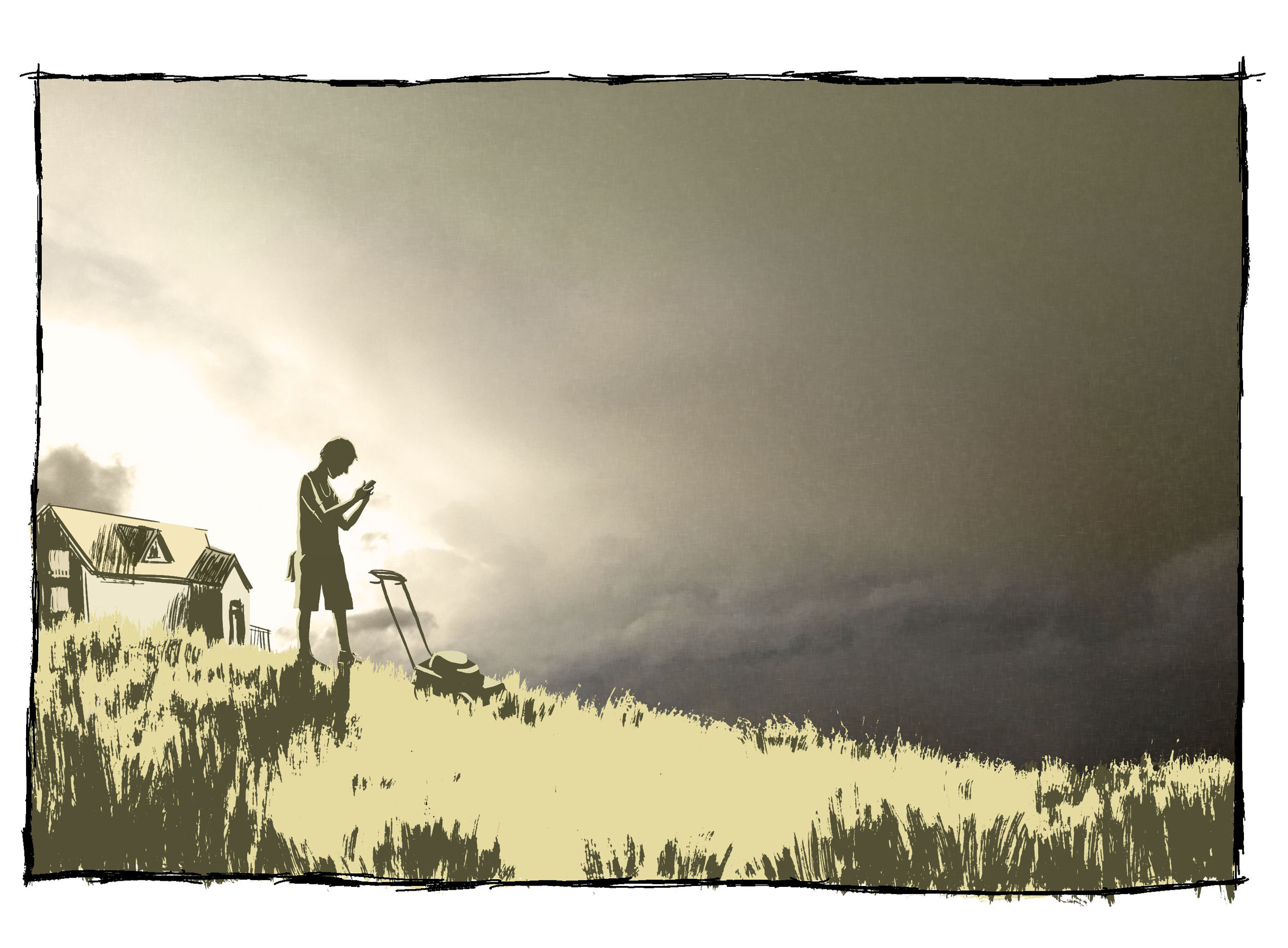
At about the same time, meteorologist Mike Griffin pushed a lawn mower across his yard on the south side of Springfield, cutting through both the grass and the air, thick with moisture.
Every few minutes he stopped to check the weather on his iPhone.
A colleague called.
Hey, we have stuff developing, stuff developing out in Kansas. Try to come in as soon as you can.
Setting out on the 15-minute drive to the weather service offices, Griffin examined the sky.
Well, there they are, he told himself as he examined the storm clouds. They’re going.
Off to the west, toward Joplin, ominous towers of thunderheads were bubbling up on the horizon.
4:20 p.m.
One county away in Kansas, the supercell, a behemoth on radar, grew in size and intensity. Air rushing into the storm from the south and southeast generated so much turbulence and lift that two new supercells fired south of the original one.
The new storms darkened the sky around Columbus, Kan., in Cherokee County, 25 miles west and slightly north of Joplin, and hurled baseball-size hail.
Now three churning supercells were marching eastward.
4:30 p.m.
Keith Stammer knew something was about to pop in Joplin. It was still early enough in the day for heat to trigger a tornado, or at the very least a severe thunderstorm.
A call from Cherokee County confirmed his suspicions.
We’ve got this storm; we’ve got rotation. We’re trying to figure out if we’ve got a funnel or not.
Stammer decided to head to the bunker, the windowless, Cold War-era basement of the municipal building downtown that was his command central during emergencies. He told Kathy to grab her knitting; she always goes to the bunker with her husband.
Stammer called their daughter, Karyn, 31.
Where are you? he asked her.
I’m just leaving Oswego and heading for Joplin, said Karyn, who had her 4-year-old son and 1-year-old daughter with her.
Oswego was safely behind the line of storms.
Turn around and go back, Stammer warned. Do not come this way.
4:45 p.m.
A fourth supercell fired, blocking out the sun near Baxter Springs, Kan., 15 miles from Joplin and well south of the three other cells. Eyewitnesses stared up into its twisting open center as it passed overhead.
5:03 p.m.
The graduates of Joplin High School’s class of 2011 threw their caps into the air.
Outside in the parking lot, Joan Phillips sat in her Buick Enclave with her husband, Larry, listening to radio reports that a bad storm was heading into town. Phillips grew anxious as it started to rain. She wanted to leave, but her grandson, Chris, who played in the band, was still inside.
5:09 p.m.
The two supercells in the middle of the group of four merged near the Kansas-Missouri border. Radar showed the core of the merged cells was spinning rapidly one to two miles above ground level.
Storm spotters reported several funnel clouds near Columbus, Kan., but nothing on the ground.
In Springfield, forecasters issued a tornado warning for western Jasper County.
5:11 p.m.
Keith Stammer had seen enough. The rotating core, or mesocyclone, on the radar was tracking toward the college where high school graduation had just ended. The storm was rapidly shifting and confusing, even to experienced forecasters.
Stammer decided to jump the gun, even though the tornado warning did not yet include the city of Joplin.
“My philosophy is pretty straightforward on this,” Stammer said. “In the morning, after it’s over, I’d rather be criticized for overreacting than crucified for underreacting.”
All 28 outdoor sirens across Joplin began to wail.
Band director Rick Castor waited around to take pictures with a couple of seniors. When the sirens began blaring, one of the girls started crying and left. But there was no panic. In the parking lot, which faced sunny skies to the east, people walked calmly to their cars, shouting good-byes.
They couldn’t see the storm in from the west until they started to drive away.
As the sirens blew, Phillips was making a mad, 15-minute dash toward her home on the south end of town, driving through the area that would take the worst hit. She chilled at the very thought of a tornado.
The drivers in front of her seemed to be dawdling.
Get out of my way! I want to go home! she exclaimed. I’m not from Missouri. You don’t have to show me anything!
Her grandson tried to calm Phillips as he watched the storm approach on a weather app on Phillips’ Blackberry. We’re fine. We’ve got about 10 minutes.
Christopher, I don’t want to hear it! I want to get home!
5:17 p.m.
Just east of the state line, the Baxter Springs supercell flowed into the larger tangle of storms heading toward the college. The merger seemed to disrupt the storm that had prompted the tornado warning, reducing the threat to the northern part of the city.
Just as quickly, a new spinning core spiraled up in the southern part of the storm.
Forecasters quickly drew a projected path and issued a new tornado warning: All of Joplin was in danger.
The warning blared from weather radios and streamed across the bottom of TVs all around town, even though no tornado had been seen on the ground.
Andy Foster from the weather office in Springfield called Stammer.
The storm is moving kind of slow, about 35 miles per hour.
Stammer had hoped it was faster. Faster storms tended to inflict less damage.
5:24 p.m.
The huge snarl of a storm further darkened the skies west of Joplin. Rain from the edges of the storm wrapped around the spinning mesocyclone where the tornado was brewing, making it difficult to see. Yet another new cell, the fifth, fired southwest of the storm mass, blowing even more rain toward the city and eventually joining with the others.
A call from the public came into the bunker.
Why did you run the sirens? the woman wanted to know. Nothing’s happening.
One minute later, a new report was transmitted to weather radios and TV scrolls: A funnel cloud had been sighted 10 miles due west of Joplin.
Crossley had called her mother, Peggy Gettler, in Texas, to talk about an upcoming family vacation. Then she called her mother back.
Mama, have you talked to Aunt Anabelle? she said, referring to her aunt living west of Joplin in Kansas.
No, I haven’t.
Would you call her and check on her because a tornado is coming her way … coming toward their house. Make sure she’s OK.
Minutes later Crossley’s mom called back. Aunt Annie was OK.
But she’s telling me to call you and tell you there’s one coming toward Joplin. You and Chaz run for cover and get somewhere safe!
We will, Mama.
Crossley next called Angela, her roommate, who was out of town having dinner with her parents, to tell her a storm was headed for Joplin. Despite her mom’s concern, neither Crossley or her roommate thought the storm would be that serious.
Save my puppy, her roommate joked.
I will, said Crossley, but I’m going to save Chaz first.
Chaz had been at a friend’s house, but the parents sent him home because of the forecast. Chaz asked his mom to fix his favorite snack. She put a few pieces of bacon in the microwave.
Foster placed a third and final call to Stammer.
Whatever is out there, it’s headed straight for Joplin.
5:29 p.m.
Foster and his colleagues watched onscreen as the southern part of the mass of storms continued to intensify. Things couldn’t look worse. But at that moment the tornado was still purely potential.
Experienced forecasters know even the scariest supercells often fail to spin off a tornado.
5:31
Stammer ordered his staff to blow the tornado sirens again.
As they wailed, Trimble, Mo., meteorologist Jon Davies and his wife, Shawna, were driving southward through Joplin, chasing the storm.
By the time they reached Interstate 44, just south of the city, visibility was poor and getting worse.
Davies’ eyes, sharpened from 27 years of chasing, fixed on a worrying sight that Crossley could not see from her house.
At the western edge of town a messy gray curtain of rain, with a weirdly hazy middle, filled the sky and cloaked the danger Davies’ instruments and intuition told him was there.
The storm spooked him.
Let’s get the hell out of here, he said.
5:34 p.m.
All Foster and his colleagues could do now was sit and wait for new radar images, which only load every five minutes.
The tornado spawned by the merged supercells began its terrorizing grind through Joplin near 21st Street and Black Cat Road, 2 1/2 miles due west of Crossley’s house.
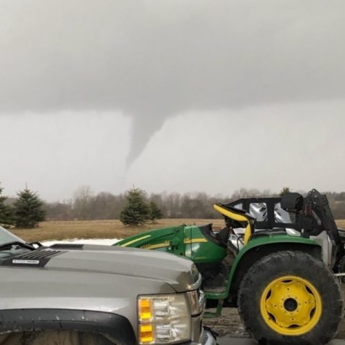
Two ghost-white dancing twisters emerged from the darkened sky and in 90 seconds widened into a single 3/4-mile-wide spinning vortex, savage and almost inconceivable in its intensity. Winds parallel to the ground blasted apart buildings and trees near the center of the tornado while updrafts and downdrafts at the edges rocketed debris into the sky and back to Earth.
5:39 p.m.
The forecasters in Springfield stared at the radar in disbelief: The messy blob from minutes earlier had morphed into a near perfect comma shape, with wind speeds maxed out in opposite directions.
Crossley’s house began to shake.
They had no basement. So she and Chaz ran outside behind the house to the crawl space. She wanted to hide him there but was afraid he would get stuck. They ran back in.
Chaz would later remember that his mom’s hands were shaking, too.
Chaz, get the dog. Let’s go get in bed and cover our heads up, she said, crying.
5:44 p.m.
Forecasters watched the pink debris ball load on the radar.
Two and a half miles east and slightly north of Crossley’s house, Rick Castor talked to his mom about the weather on his cellphone as he walked through the front door. He’d run home to take off his dress shoes before heading to Walmart to buy groceries and meet some of the band students at a new frozen yogurt place. The sirens had stopped and the weather on the drive home hadn’t looked too bad, a little rainy. He had no idea a tornado was on the ground.
As he bent over to untie his shoe the outer screen door slammed open against the side of the house. Then the inside door blew open, wind roaring into the house.
Oh my gosh, it’s here! he yelled to his mom.
Who’s there?
The tornado!
Epilogue
Malisa Crossley died. She and her son, Chaz, and the dog, Frappé, were found at the base of a tree across the street from their home, which was destroyed. Her arms were wrapped around Chaz and the dog, who survived.
Joan Phillips made it home to her basement, where she survived the storm.
Rick Castor safely rode out the storm in his bathroom.
The tornado lifted at 6:12 p.m. after traveling on the ground for 13.8 miles and 36 minutes.
Two days after the Joplin tornado, the same storm system spawned an EF5 tornado in Oklahoma City, killing nine on the outskirts of the city, before finally weakening and drifting out over the Atlantic Ocean.
Read more here: http://www.kansascity.com/news/special-reports/joplin/article77530012.html#storylink=cpy