The National Weather Service confirmed an EF0 tornado caused damage in New Orleans overnight Tuesday as severe thunderstorms blew through the area and produced flooding. Power poles were toppled and tree damage was reported, with the storms knocking out power to as many as 10,000 people for a time.
The Weather Service was out surveying damage Wednesday afternoon to determine whether a tornado did touch down. The agency issued a tornado warning at 2:08 a.m. Central time when strong rotation was detected in a thunderstorm.
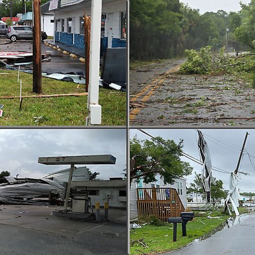
A power pole was knocked onto a car at the intersection of Cohn and Lowerline streets in New Orleans, where the roadway was blocked by a fallen tree. Debris was reportedly scattered in New Orlean’s Federal City neighborhood on the corner of Behrman and Opelousas avenues.
Images posted to social media revealed structural damage to homes, including what appeared to be a large beam tossed into a building.
Trees were uprooted and traffic lights were knocked down, while a number of homes lost siding, pieces of walls and even sections of roof.
Damage was commensurate with 85 mph winds, equivalent to a very high-end EF0 tornado on the 0-to-5 scale for twister intensity.
The agency released the results of the survey which confirmed the tornado just after 4 p.m. Central time.
“We have damage reports all over uptown New Orleans into Algiers Point,” said Kevin Gilmore, a forecaster at the Weather Service in New Orleans. “It cut through New Orleans in the central business district and almost into the French Quarter as well.”
He described the damage as “pretty hit or miss along where [the] possible track was,” meaning the tornado may have skipped at times.
In an unusual turn of events, the tornado warning issued Wednesday morning was the second in 13 hours for parts of the Big Easy. Seabrook, Gentilly, West Forest Lake and Pines Village were included in a warning at 1:03 p.m. Central time on Tuesday afternoon; the warning remained in effect for 15 minutes and was dropped when the storm weakened.
The next one came at 2:08 a.m. Wednesday, activating wireless emergency alerts to wake residents and direct them to shelter at a time when most were asleep. There were no immediate reports of casualties.
The tornado first touched down in Uptown New Orleans between Claiborne and Carrollton Avenues, moving east and peeling back the metal roof on a commercial building near an Amtrak terminal. The tornado moved through the Central Business District and crossed the Mississippi River, eventually lifting near the Naval Support Activity Center, according to the Weather Service’s preliminary survey.
The agency may bump the tornado up to EF1 strength with a later update, since the 85 mph winds estimated by damage thus far in the preliminary survey are the maximum still included within the EF0 category.
The instigating storm was one cell in a line of strong thunderstorms that moved in from the west. Low-level wind shear, or a change of wind speed and/or direction with height near the surface, helped induce “kinks in the line,” or embedded rotations that can cause quick tornado spin-ups.
Rotation was visible on radar south of Interstate 10 in Hahnville, about 15 miles west of New Orleans, around 1:15 a.m. That rotation intensified east of Saint Rose, near the Mississippi River about five miles southwest of Louis Armstrong International Airport, at 1:30 a.m.
It appeared that a weak localized boundary along the southern edge of Lake Pontchartrain may have provided enhanced low-level helicity, or spin, that the storm could ingest.
At 1:58 a.m., the Weather Service issued a severe thunderstorm warning for the cell as it marched into town, probably to raise awareness in the event a tornado warning was later issued. Rotation at 2:04 a.m. remained broad; while inflow, or warm air surging in from the south on the east side of the circulation, was plentiful, the rear flank downdraft, or cool air on the backside of the storm needed to tighten the rotation, was still organizing.
Just 1 minute 54 seconds later, however, the next radar scan showed a much stronger rotation. Winds at 1,900 feet above the ground were moving toward the radar at 64 mph, with nearby winds heading away at 17 mph. That reflects a rotation of 81 mph near the cloud base; rotation reaching the ground was probably more concentrated and stronger.
The tornado touched down at 2:05 a.m., three minutes before the warning was issued.
The Weather Service waited for one more radar scan before pulling the trigger; storms of this type have a tendency to pulse up and down very quickly. The rotation at the time was south of Xavier University of Louisiana.
At 2:07 a.m., the rotation intensified to 92 mph less than 2,000 feet above the ground, prompting the Weather Service to issue a tornado warning for downtown New Orleans and points east. The tornado remained on the ground until 2:12 a.m., tracking 5.26 miles with a path up to 125 yards wide.
The last tornado in New Orleans, a destructive EF3, touched down on Feb. 7, 2017, east of the Industrial Canal and moved toward Lake Borgne. Thirty-three injuries were reported, including six serious injuries.
by Matthew Cappucci (2021, May 12) The Washington Post