Oklahoma, lying in the heart of Tornado Alley, is famous for its frequent twisters. But 2019 took the twisting tempests to another level.
The Sooner State’s tornado count climbed to 146, including the swarm of 105 during May. This number eclipses the previous record of 145 tornadoes set in 1999.
But whether 2019′s tornado total is truly a record is up for debate. It may simply reflect that we’ve gotten better at detecting and spotting these storms.
After a slow start, a tornado onslaught in late April and May
After a record slow start to tornado season in 2018, it seemed likely that 2019 was on a similar course. Two tornadoes had touched down before the last day in April, whereas Oklahoma’s average tornado count through then is 16.
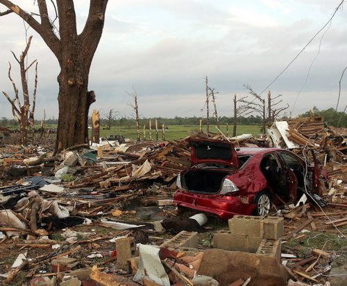
But 20 tornadoes spun up April 30, including a killer EF3 near the town of Bryan. That one was three-quarters of a mile wide.
May roared in, with five funnels whirling in Love and Jefferson counties, along the Red River in southern Oklahoma. All were rated EF0s or EF1s on the 0-to-5 scale for tornado intensity — with two designated “EFU,” meaning they were left unrated because of a lack of damage indicators from which to derive wind speed estimates.
Nine twisters touched down the next week, followed by a 10-day lull.
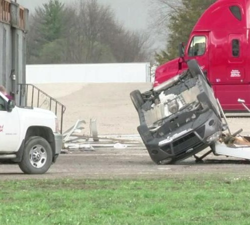
A period of fury ensued beginning May 17, with more than 300 tornadoes swarming across Tornado Alley and the Lower 48 during the final days of May. On May 29, the United States observed its 13th straight day with eight or more tornadoes, setting a record.
On May 17, only one tornado swirled through the Sooner State; the rest battered Kansas, Nebraska and Texas.
A day later, it was Oklahoma’s turn to rage. Nine tornadoes dropped on May 18; 26 on May 20; and 42 over the next five days.
On May 22, a morning forecast of enhanced severe storm potential quickly blossomed into a full-fledged tornado outbreak. The Storm Prediction Center plastered northeast Oklahoma, southeast Kansas and much of Missouri under “particularly dangerous situation” tornado watches. A storm system then spawned 42 tornado reports well into the night.
The same outbreak also prompted a rare “tornado emergency” for northern suburbs of Joplin, Mo., with an EF3 tornado passing just north of town. It was the eight-year anniversary of the EF5 tornado responsible for razing much of Joplin, which killed 161 and was the deadliest U.S. tornado since 1947.
What sparked this year’s tornado swarms?
The flurry of activity that defined the 2019 tornado season was no fluke. It was one of the most favorable patterns for widespread severe weather in years.
A large trough of low pressure remained banked up to the west over the Rockies, ejecting energetic disturbances over the Plains. Ahead of it, persistent moist flow from the Gulf of Mexico continued to refuel the atmosphere before each system, generating round after round of storms.
Ordinarily, bouts of severe weather occur with a few days in between. But not this year. It was back-to-back-to-back, relentlessly plaguing the same areas, thanks to that constantly reloading atmosphere.
It was a pattern that favored serious flooding, as well, with repeated rounds of moisture leading to double-digit rainfall totals in a matter of days. Flood sirens sounded along the Arkansas River near Tulsa, where flash-flood emergencies were hoisted after nearly a foot of rain.
When atmospheric features stall, it can bring “feast or famine” weather. Unfortunately, this year was a smorgasbord of severe weather and flooding.
The record set
2019 wound up with 146 tornadoes in Oklahoma. Only five other years since 1950 have seen 100 or more tornadoes. And 2019 narrowly beat out 1999, which recorded 145 tornadoes. 2019 also claimed top spot for most Oklahoma tornadoes in a month — 105 in May — with the 91 in 2010 or 90 in 1999 trailing a bit behind.
Much of 1999′s total came from the infamous May 3 tornado outbreak, during which eight supercell thunderstorms unleashed 58 tornadoes in and near the Oklahoma City metro area. Among them were three F4s and one F5, the latter destroying most of Moore, killing 36, and sparking the creation of the tornado emergency alert.
But did we really set a record? 1999 vs. 2019
2019 edged out 1999 by a hair. Or did it?
In 1999, 42 people in Oklahoma were killed by tornadoes. This year, that number stands at four. The lower number of deaths is partially a product of vastly improved weather warning systems and enormous strides in predictive ability, but there may be more to the story.
1999 featured two F4 tornadoes and an F5. Eleven F3s occurred as well. (Note, the 0-to-5 Fujita or F-scale for classifying tornadoes used in the late 1990s was changed to the Enhanced Fujita scale in 2007). This year, there were no EF4s or EF5s, with only three EF3s.
1999 appears to have had a greater proportion of stronger tornadoes, but that may be because some of the lower-end tornadoes were missed. It’s likely that better detection and reporting is leading to the detection of more low-end tornadoes nowadays that would simply have been missed in 1999.
How can we tell? Let’s talk “significant tornadoes,” or any twister that reaches/exceeds F2/EF2 strength. Twenty percent of the tornadoes that touched down in 1999 were rated as significant; less than 9 percent of this year’s were. That’s because we’re seeing a greater number EF0s and EF1s get rated nowadays, probably because of improved radar technology, the proliferation of mobile camera phones and the ease of reporting from afar. There are also far more storm chasers on the roads, swarming around storms, making it challenging to miss even the most fleeting spin-ups.
This year also featured 33 “EFU” or “unrated” tornadoes. If a tornado touches down in a rural area and produces no damage, the National Weather Service may opt to not conduct a damage survey. In 1999, any tornadoes that went without damage were simply listed as F0s.
If we lump the number of EFUs and EF0s from this year and compare it with the number of F0s in 1999, we get a close match. A large disparity exists, however, between the number of EF1 (or F1) tornadoes between the two years: 36 in 1999, and 60 in 2019. It’s another sign we’re now catching and counting some of the less-intense tornadoes.
Enormous strides in detection: Dual-polarization radar
Dual-polarization radar, referred to by meteorologists as “dual-pol,” has revolutionized the way we can track and monitor severe storms in real time. With better resolution and improvements in scanning rotation patterns to probe the lowest levels of the atmosphere more frequently, finer-scale circulations can be caught ahead of time, their precursors prompting a warning on what otherwise may be a “missed event.”
This is no truer than with QLCS tornadoes — or ones born from “quasi-linear convective systems.” In essence, squall lines with several little bends, QLCSs often feature embedded areas of spin, thanks to their strong wind shifts. Tornadoes can drop from these miniature mesocyclones, or “misocyclones,” with little or no warning, the transient vortex on the ground for a minute or two before sneakily dissipating. In the past decade, meteorologists have become adept at detecting them.
Case in point? May 25. The National Weather Service in Norman, Okla., spotted a developing circulation that would never have been adequately resolved 20 years ago. It issued a tornado warning for El Reno at 10:26 p.m. At 10:28 p.m., a narrow, 75-yard-wide funnel carved through a hotel, killing 2 and injuring 29. It lifted barely two minutes later. It was rated an EF3. Most QLCS tornadoes are EF0s or EF1s.
If that kind of funnel spun up over a rural area in 1999, it would almost certainly not have made the count. With greater indications of where short-lived funnels may have spun up, it’s easier for the National Weather Service to pinpoint areas of tornado damage within wider swaths of damaging straight-line winds with QLCSs, too.
The verdict
2019 was an impressive year for tornadoes. But no day in May this year could ever compare to the infamous outbreak of May 3, 1999. Moreover, 1999 very likely featured more tornadoes than 2019 in Oklahoma, but enormous improvements in detection and reporting made it harder to miss an event in 2019.
“I think it’s important to think about what’s different 20 years after 1999,” wrote Rick Smith, warning coordination meteorologist at the National Weather Service office in Norman, Okla. “In our area, it’s rare to have a tornado without images or video. We have improved radar technology that allows us to see signals of a tornado and debris within a storm better than we used to. And we have social media, which gives people a place to share their [pictures], videos and reports. Had we had all that back in 1999, I have to believe the number of tornadoes would be higher.”
by Matthew Cappucci (2019, Dec 17) The Washington Post