The National Weather Service confirmed that five tornadoes touched down across the region last Thursday, May 4.
All five tornadoes were considered EF1s on the Enhanced Fujita Scale, meaning wind speeds never exceeded 110 mph.
The tornadoes touched down in Chatham County in Georgia and Colleton, Dorchester and Orangeburg counties in South Carolina.
Although the Chatham County tornado was confirmed just south of Beaufort and Jasper counties, no significant damage was reported in either county.
Garden City
According to the weather service, the first tornado touched down near Garden City — located just outside of Savannah — around 5:50 p.m. on May 4.
The report says the tornado began near Seaboard Coastline Drive and Telfair Junction roads, moved north toward Alfred Street, continued south of Hwy. 80, then dissipated over the Savannah River.
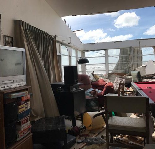
The tornado reached its strongest point — with wind speeds near 110 mph — as it reached the area south of Hwy. 80. Significant damage occurred to the Advanced Auto Parts store.
“Three walls collapsed and the roof was heavily damaged and shifted halfway off the remaining rear wall,” the report read.
Five cars outside the store were “heavily damaged from the front wall of the store falling on them,” according to the weather service.
The service also reports that five people who were inside the store were injured by the tornado.
Hendersonville
After the storm system moved over Beaufort and Jasper counties, another EF1 tornado formed in Colleton County near Hendersonville around 7:45 p.m.
According to the weather service, this tornado touched down off I-95 just south of the Hendersonville Rest Area.
The tornado had a path of 12.56 miles, according to the weather service.
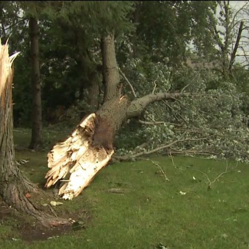
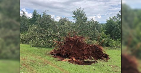
More than 100 trees were snapped or uprooted along this path. Damage to power lines, homes and other property also occurred.
Significant damage was reported on Cane Branch Road.
The weather service reports that a 6500 lb. boat and trailer were “displaced about 30 yards from their original position, a golf cart (was) lifted up and moved about 20 yards… (and) the house was shifted a bit on its foundation.”
The tornado moved north toward Route 63, and damaged a mobile home and barn, “tossed a trampoline into a tree line about 20 feet off the ground,” damaged three other mobile homes and a two-story home, and snapped two power poles, according to the weather service.
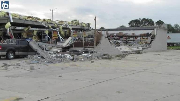
The worst damage occurred near a shopping complex along Highway 64 where it severely damaged 1000 trees, the report said.
The tornado had an estimated maximum width of 1/4 mile and maximum wind speeds of 110 mph.
No injuries were reported, according to the weather service.
Walterboro
A second tornado touched down in Colleton County near Walterboro around 8:16 p.m.
The weather service reports this tornado touched down west of McLeod Road, then moved northeast just north of Allen Creek.
The tornado had an estimated path of just over six miles, and reached winds speeds of around 100 mph, according to the weather service.
A home was damaged along McLeod Road, and at least 100 trees were damaged along the tornado’s path.
The tornado dissipated just south of the Edisto River, the service reports.
No injuries were reported.
Canadys
This tornado touched down as the second tornado was dissipating — around 8:25 p.m. — according to the weather service.
The twister traveled a little over two miles across Colleton and Dorchester counties, damaging trees along its path as it reached wind speeds around 100 mph.
No injuries or property damage was reported.
Holly Hill
The final tornado touched down in Holly Hill, located in Orangeburg County, around 9:00 p.m.
The EF1’s path was about three miles long and 150 yards wide, and wind speeds reach 103 mph, according to the weather service.
The Post and Courier reports the storm was the first tornado to touch down within Holly Hill’s city limits since April 29, 1959.
Vehicles and trees were damaged along the storm’s path, according to the weather service.
The service also reported that two trees fell on a mobile home located on Cocoa Circle southwest of Holly Hill. A mother and daughter were inside the home during the tornado and were later rescued by the local fire department, according to the report. The two women were not injured.
The metal roof was also ripped off of part of a strip mall located with Holly Hill city limits, according to the weather service.
Lowcountry tornado history
Only 25 tornadoes have been reported in Beaufort and Jasper counties since 1990, according to the South Carolina Department of Natural Resources.
Eighteen of these occurred in Beaufort County, and seven were reported for Jasper County.
The majority of the counties’ tornadoes have been considered EF0 — the weakest category in the Enhanced Fujita Scale. Wind speeds in an EF0 do not exceed 85 mph.
Beaufort County reported three EF1 tornadoes, two in 1995 and the third in 2004.
The worst tornado to touch down in Beaufort County since 1990 was an EF2 tornado on Sept. 3, 1998.
The tornado spun off of Hurricane Earl, and touched down just east of Frogmore on St. Helena Island. More than $350,000 in property damage was reported, and the storm resulted in the county’s only tornado-related fatality.
Jasper County has had five EF1 tornadoes. Two touched down in April 1998, another two in September 2004 and the most recent on June 11, 2012.
The 2004 tornadoes spun off of Hurricane Frances. One injury was reported on Sept. 6, 2004, when a tornado touched down near Hardeeville. The second EF1 tornado touched down in Gillisonville, but no injuries were reported.
by Ashley Jean Reese
May 11, 2017