At least one injury has so far been confirmed from the tornadoes which made their way across Crawford County Tuesday afternoon.
According to Patrick Faunders, meteorologist with the Cleveland National Weather Service (CNWS), the group has received only a single report of an injured person by around 6:40 p.m. on Tuesday, and no cases of fatalities. Faunders said that he was unable to release further details regarding the injury.
Further, while the service issued three tornado alert warnings, it had only confirmed one touchdown. Faunders said that a tornado was confirmed to have formed and touched down in the area of Conneautville, resulting in damage to a care center.
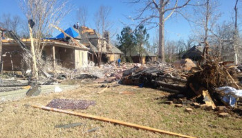
A press release from the Crawford County Department of Public Safety issued Tuesday said that the tornado damaged a villa and portion of the main facility at Rolling Fields Eldercare, around 2:41 p.m. Although the release listed two minor injuries as having occurred, a separate press release from Rolling Fields said that two residents were hospitalized for “unrelated concerns.” It is unclear if both press releases are referring to the same people.
Public Safety Director Kevin Nicholson said that the roof of the villa was torn off, and a gas leak resulted from tornado damage. While the leak was taken care of “pretty quickly” according to Nicholson, the 162 residents of the care center were taken to Conneautville Fire Department and Conneautville Middle School for shelter. The latter shelter was operated by area divisions of the American Red Cross.
Two tornado warnings were issued over the course of Tuesday. According to Faunders, these warnings were issued based off of radar detection. It has not yet been separately determined how many tornadoes touched down in those areas.
The two warnings were issued at 3:14 p.m., and regarded “large and extremely dangerous tornadoes” detected near Cambridge Springs and Pymatuning North. The latter tornado was the one that damaged Rolling Fielders.
The Cambridge Springs tornado moved eastward, and approached Titusville and surrounding towns.
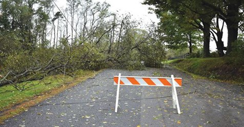
The Hydetown Volunteer Fire Department (VFD) responded to downed trees and electrical wires along Mystic Park Road, about 4 miles northwest of Hydetown. There were also downed trees on Bog Hollow Road, two miles north of Hydetown.
Titusville Fire Department Chief Joe Lamey said that Titusville was relatively untouched by the storm, with no reports of major damage outside of some storm drains clogged by leaves.
“It must have gone right around us,” Lamey said.
Despite not being hit, children in the Titusville Area School District were kept in their respective places of learning for two extra hours until the storm warnings expired. Director of Student Services Amy Herman contacted parents with children in the district via a recorded message around 4:30 p.m. telling them that the kids would be kept longer, and sent out a second message around 5:20 p.m. about the kids returning home two hours later.
Townville was similarly spared of any major damage, according to Townville VFD Assistant Fire Chief Josh Manuel. However, the department did assist Blooming Valley with multiple downed trees.
The Herald reached out to Pleasantville VFD, but did not receive any reports of damage by time of publication.
Faunders said that the CNWS will be sending out survey teams to inspect the county today to determine damage and number of tornadoes.
While a tornado watch and flash flood advisory were initially sent out by the CNWS to last until 11 p.m. Tuesday, they were both cancelled ahead of their deadline around 5:40 and 5:26 p.m. respectively.
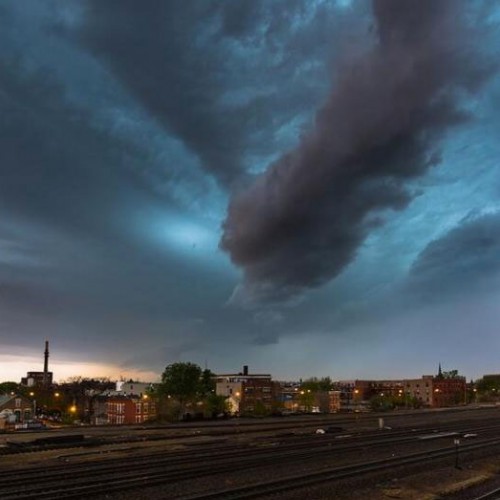
Stormy horizons
While additional tornadoes are unlikely, CNWS Meteorologist Mike Griffin said there may be more severe storms in the near future, possibly even later this week.
Griffin said that Crawford County is currently experiencing a warmer fall than usual, with average highs in the 80s. At the same time, a cold front moving into the county is reacting to these warm temperatures, and causing volatile weather.
The collision of a cold front with a warm environment forms something called a “supercell,” according to Griffin.
“They’re the worst type of severe weather storms,” Griffin said. “Typically you see a lot of them out in the tornado alley.”
Griffin said that tornadoes require an exact set of circumstances to form, and that it isn’t likely those circumstances will occur again during the supercells. However, rain and intense winds are a possibility.
“We’re not completely out of the woods for some active weather,” Griffin said.
While stormy weather is something usually associated with spring, Griffin said that fall, particularly October, is a secondary severe weather season for the year.
Herald Sports Editor Zack Borland contributed reporting to this article.
by Sean P. Ray (2018, October 3) The Titusville Herald