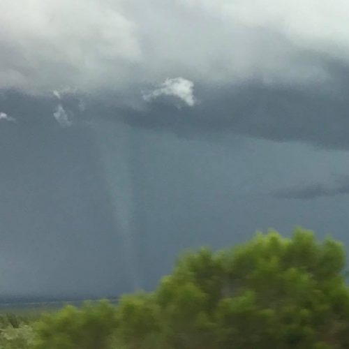
A New Hampshire tornado in early May was one of the longest tornadoes on record to track through New England, the National Weather Service said.
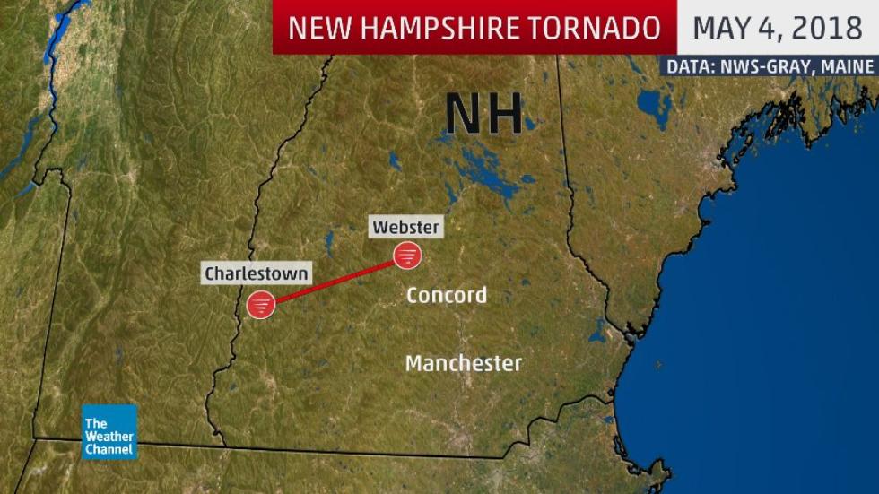
According to a just-completed NWS damage survey, a tornado was in progress May 4 south-southeast of Charlestown, New Hampshire, just east of the Vermont border in Sullivan County. It then tracked about 36 miles east-northeast for 33 minutes to its endpoint near the town of Webster in Merrimack County, just over 10 miles northwest of the state capital, Concord.
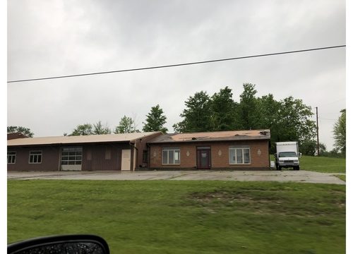
The most significant damage was near the town of Warner, where estimated winds of 90 to 100 mph prompted a rating of EF1 on the Enhanced Fujita scale, according to John Jensenius, Warning Coordination Meteorologist at the NWS office in Gray, Maine.
The record of longest tornado tracks is subject to some uncertainty due to both fewer tornado reports in past decades before spotter networks, Doppler radar and smartphones became pervasive, and also from past grouping of adjacent individual tornadoes into one seemingly longer-track tornado.
With those caveats in mind, this New Hampshire tornado’s path was the state’s second-longest on record.
According to the Tornado History Project, the longest tornado path in New Hampshire since 1950 occurred on July 24, 2008, when a 50.46-mile-long EF2 tornado touched down just east of Concord, then tracked northeast near the town of Freedom.
That July 2008 tornado was also the longest tornado path on record in New England since the mid-20th century.
There were only two other New England tornadoes with longer paths in the Tornado History Project database:
43.9 miles: Aug. 21, 1951 (F2 tracked from north of New Milford, Connecticut, through the Hartford metro area)
37.6 miles: June 1, 2011 (EF3 tracked from just south of Westfield through Springfield, Monson, and Sturbridge, Massachusetts)
The Detective Work
On May 4, it wasn’t obvious a tornado had happened at all.
Jensenius said NWS forecasters noted some rotation on radar at the time of the tornado. However, the beam from the Doppler radar site just north of Portland, Maine, over that part of southern New Hampshire was a significant height above the ground.
Amid a swarm of thunderstorm wind damage and high wind reports, how did the NWS suspect a tornado?
“Wind damage reports from the public trickled in days after the storm,” said Jensenius, who also surveyed the state-record tornado path in July 2008. “Piecing all these reports together, we wondered if there was indeed a tornado path.”
Ten days after the event, on May 14, NWS-Gray conducted their storm survey, driving three hours from their forecast office north of Portland, Maine, to southern New Hampshire, crisscrossing roads in Sullivan and Merrimack counties.
Jensenius said there were several inaccessible areas within the swath, including a state park that was still closed for the season, and heavily wooded and/or mountainous terrain.
This included some hilly terrain just west of the initial touchdown point, south-southeast of Charlestown. Jensenius said it’s possible the tornado may have begun earlier due to this terrain.
This was also the second-earliest-in-season tornado on record in New Hampshire, topped only by a May 3, 1976 F2 tornado near Portsmouth.
by Jonathan Erdman (2018, May 15) The Weather Company