The historical comparisons are evident.
The National Weather Service’s Paducah office – which assessed the damage from the Perryville tornado – released its final storm report on Saturday.
According to the NWS, the twister is not only the longest-track tornado in this region since 1981 – spending an incredible one hour and 2 minutes on the ground – but its parent supercell thunderstorm also followed a similar path to that of the 1925 Tri-State tornado.
“The tornado started northwest of Perryville, Missouri, and ended southwest of Christopher, Illinois,” said Robin Smith, a meteorologist with the Paducah office. “The widest point was six-tenths of a mile wide and the track was 50.4 miles long.
“That places it as the longest-track tornado in our coverage area since another EF-4 on April 22, 1981.”
The NWS stated the tornado originated at 7:55 p.m. on Feb. 28, almost five miles west-northwest of Perryville. It quickly reached EF-4 (violent) intensity and leveled five homes in the Kyle Lane/Perry County Road 806 area.
The tornado moved on to a nearby salvage yard alongside Interstate 55, blowing between 15 and 20 vehicles onto and over the highway. It was there where it caused its lone fatality, intercepting a southbound pickup driven by 24-year-old Travis Koenig, of Perryville.
Koenig was ejected from his vehicle, landing in a field east of the interstate.
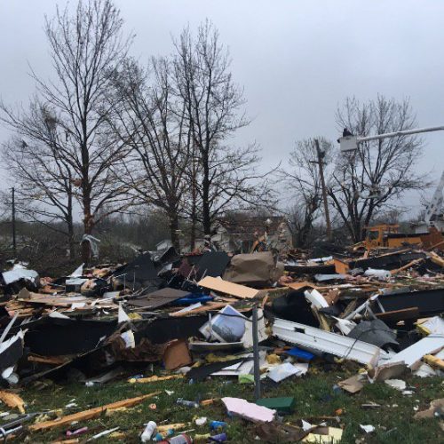
Continuing eastward, the tornado reached the Moore Drive subdivision off of Highway 61 three miles north of Perryville, where it reportedly caused its greatest amount of home and property destruction.
“Three homes were leveled on the west side of U.S. Highway 61, with dozens of other homes and structures destroyed,” the NWS said in the report. “Several of the injuries occurred in this area.
“In addition to the leveled homes in Perry County, at least 100 other homes received moderate to major damage.”
The Perry County (Mo.) Emergency Management Agency announced Thursday that its damage assessments were worse than originally estimated.
Altogether, 110 single-family homes sustained reportable damage. Of that amount, 42 were destroyed, 12 sustained major damage and 56 suffered minor damage.
The assessments only covered livable dwellings, not outbuildings or other non-residential structures.
In a news release, the Red Cross reported 162 total homes sustained at least some damage in the tornado, with 61 destroyed. Of those destroyed, 14 were in Jackson County and three in Randolph County.
An additional 24 homes were left uninhabitable by the twister, which achieved its widest point as it reached the Mississippi River.
“The tornado damage path also exhibited multiple vortex characteristics at this point, yielding three distinct convergent areas within the parent vortex,” the report said. “This was also indicated via ground striations, or disturbance marks to bare ground, just west of the Mississippi River.”
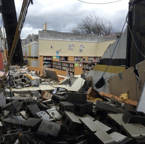
After crossing the Mississippi River, the tornado clipped the southern part of Randolph County near Rockwood, debarking and uprooting trees and destroying many outbuildings.
From there it continued east-northeast into Jackson County, where it passed south of Ava and Vergennes and struck northern Elkville before entering Franklin County.
“Many thousands of large trees were snapped and uprooted, and dozens of homes and other structures were damaged or destroyed across Jackson and Franklin Counties,” the report said.
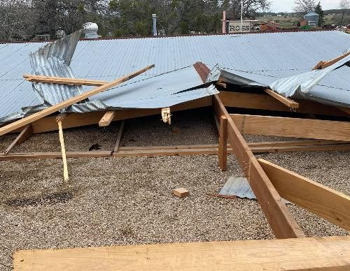
The tornado remained very intense and was a third of a mile wide when it leveled a home a mile and three quarters south of Mulkeytown.
“Very soon thereafter the tornado began to rapidly weaken, before dissipating 1.8 miles southwest of Christopher,” the report said.
At least 12 people in total were injured by the twister, which had peak winds of an estimated 180 mph.
The thunderstorm responsible for the Perryville tornado also spun out an EF-3 twister northeast of Carmi that started at 9:54 p.m. and tracked 44.6 miles to Oakland City, Ind., before dissipating at 10:45 p.m., Central time.
That tornado had peak winds of 152 mph and killed one person and injured two others; while damaging or destroying at least 153 structures that ranged from single-family homes to farm buildings.
“These tornadoes that we had paralleled the Tri-State tornado track,” Smith said. “It was only off by 20 or 30 miles.
“The difference is this particular supercell didn’t produce a tornado consistently.”
Two other smaller tornadoes – an EF-0 and an EF-1 – also touched down in Jackson and Williamson counties during the outbreak, but only caused tree damage.
Smith was asked if it was rare to have tornadoes in February.
“We have tornadoes in every month of the year in our warning area,” said Smith, who noted the Paducah office includes most of Southern Illinois in its coverage. “What is rare is the intensity and length of the tracks.
“That’s what makes this event significant or unique. How strong (the tornadoes) were and how far they tracked.”
by Pete Spitler
updated: 3/5/2017 4:23 PM