Weather forecasters can now provide about 15 minutes of warning before a tornado hits an area, but an advanced satellite detection system developed in Palo Alto could increase that to 30 minutes.
The Geostationary Lightning Mapper, developed by aerospace giant Lockheed Martin, is scheduled to go into orbit aboard a National Oceanic and Atmospheric Administration satellite.
“By providing increased tornado warnings, we’ll be saving people’s lives on the ground,” said Jeff Vanden Beukel, Lockheed Martin’s program director, during a press preview last week.
The Advanced Technology Center, Lockheed’s Palo Alto outpost, has also developed an advanced solar storm detection system that will provide earlier warnings of electromagnetic waves emanating from the sun that could disrupt Earth’s communications systems and electrical grid.
Both instruments will be aboard each of four weather satellites that will watch Earth’s Western Hemisphere in orbit about 22,500 miles above ground. The launch is scheduled for Nov. 19 from Cape Canaveral.
The total cost of the program, including four satellites and associated ground systems, is $10.83 billion, including 30 years of operations. Lockheed Martin will receive a portion of this total for its building and testing the satellites plus three instruments on each spacecraft.
The satellites represent an important advance in forecasting tornadoes and severe weather, said Steve Goodman, the ocean and atmospheric agency’s chief scientist for the satellites.
“This is the first major upgrade in 22 years,” Goodman said.
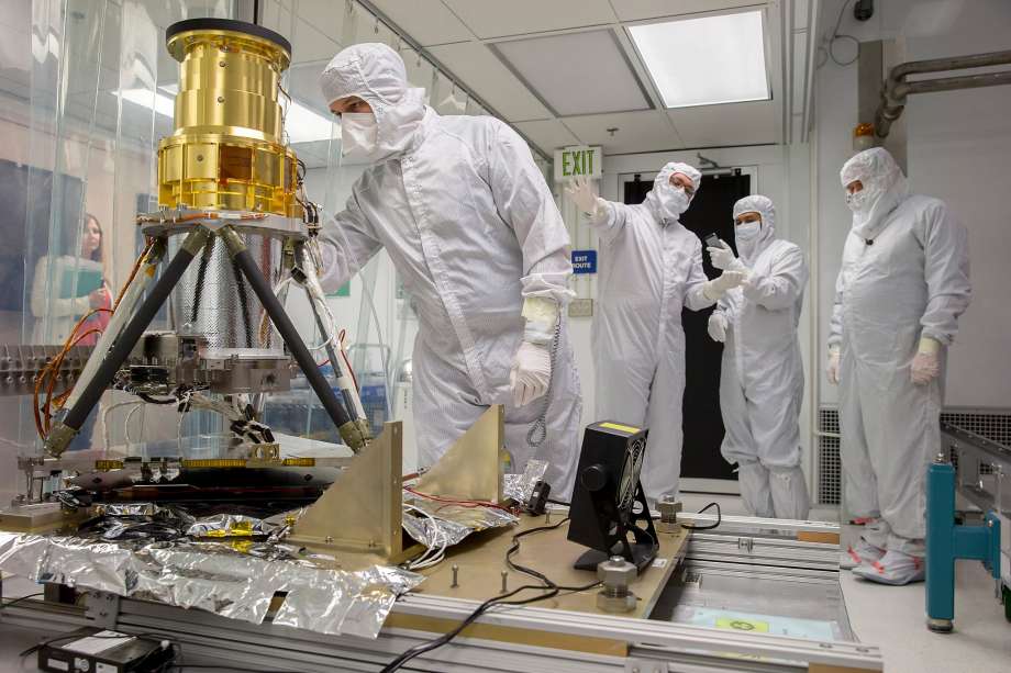
The 200-pound lightning mapper, roughly the size of a large gym bag, is a new tool for weather forecasters. It has seven high-powered lenses, protected from the conditions of space with a gold-plated cover, that snap images of clouds below at 500 frames per second; a standard video camera shoots 30 frames per second.
The images can detect lightning activity — including hail particles and ice crystals colliding to produce an electrical reaction — high up in clouds before it intensifies enough to start hitting the ground.
The information can help forecasters spot patterns that could develop into severe storms, Vanden Beukel said.
The high-resolution images can detect lightning even during daylight hours, and with the satellite’s positioning, can help airline pilots avoid severe turbulence over oceans, where there aren’t ground-based weather spotting crews, Goodman said.
“We can hopefully avoid turbulence and make your flight more efficient and safer out over the ocean,” he said.
The solar imager is an updated version of a previous model, with increased ability to detect ultraviolet light from the sun. Scientists can study the images to better understand why and when solar storms form and when flares might be headed toward Earth.
Scientists believe the imager will provide more warning time for astronauts on space walks and for satellite operators to power down before their systems can be affected. Severe solar storms have also been shown to cause brownouts and blackouts on the ground.
By Benny Evangelista November 6, 2016 Updated: November 7, 2016 12:44pm
Photo by Santiago Mejia, The Chronicle “Engineer Clinton Coates-Maldoon checks on the Geostationary Lightning Mapper at Lockheed’s Advanced Technology Center.”