Two Colorado companies are working together on the first major upgrade to the U.S. government’s weather observation instruments since the 1980s – and that means the forecast on your phone might get more accurate in the years ahead.
“It’s pretty much been black and white images of clouds since the 1970s,” said Greg Mandt, National Oceanic and Atmospheric Administration (NOAA) GOES-R Program Director. A series of space missions will bring a change as dramatic as the jump from black-and-white to HD television.
It starts this November, when Littleton-based Lockheed Martin launches a billion-dollar weather satellite aboard a United Launch Alliance rocket in mid-November.
Known as the Geostationary Operational Environmental Satellite-R (GOES-R), it’s the first of four spacecraft designed to sustain U.S. weather forecasting through the year 2030.
The new satellite carries six instruments that will help with short-term weather forecasting, seasonal predictions, severe weather watches, oceanic forecasts, drought predictions and space weather. The updated technology will help with hurricane, thunderstorm and tornado tracking and improvements to
“The instruments onboard GOES-R are the first upgrades to the GOES system since the 1980s, providing higher-resolution images of weather patterns and severe storms five times faster than today,” Tim Gasparrini, vice president and GOES-R Series program manager at Lockheed Martin said in a statement.
Previous satellite updates have been very minor, such as tweaking sensitivity and resolution or adding additional channels, Mandt explained
The new GOES-R imager will have three times the amount of channels, four times the resolution and will scan five times faster. That means that NOAA will be able to see the entire hemisphere in about five minutes, as opposed to the thirty minutes it takes today–in high resolution and full color.
Lockheed beat out Boeing in 2008 for the first $1.09 billion contract, then was later tapped by NASA and the National Oceanic and Atmospheric Administration (NOAA) to build the follow-up satellites, GOES-S, T and U, Space News reported.
How will this affect your life?
Government weather satellites, especially GOES, provide much of the data that filters down to commercial services, which means that forecasters of all sorts will be working with better information.
The most noticeable change will be in severe weather monitoring. Higher speeds and resolution mean forecasters can zoom in on storms, a tornado or lightning field, for example, and check-in every 30 seconds.
Additionally, they will be able to provide longer lead times before the storm hits, as well as more precise storm locating, so people can take action to get out of harm’s way.
After NASA’s shuttle program ended in 2011, Space Florida, the agency responsible for growing the state’s space industry, decided to refocus its efforts on bringing more commercial spaceflight to the area, Orlando Business Journal reported.
Today about 75 percent of the the $300 billion industry comes from commercial space programs like that of United Launch Alliance and SpaceX, and the Space Coast sees more launches than it has since the 1960s.
The GOES-R satellite was transported to Cape Canaveral in August and will launch Nov. 16 between 2:42 and 4:42 p.m. mountain time aboard United Launch Alliance’s Atlas V rocket.
Chloe Aiello Posted on October 26, 20163:10 pm
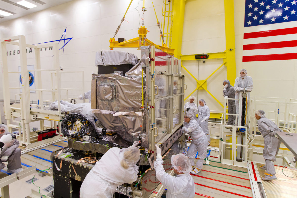
“The GOES-R Advanced Baseline Imager (ABI) is installed onto the GOES-R spacecraft at Lockheed Martin in Littleton, Colorado.” (NOAA Photo Library/Flickr)