The National Weather Service issued multiple tornado warnings, severe thunderstorm warnings and special weather alerts Sunday afternoon and evening concerning several dangerous storms that barreled through East Idaho.
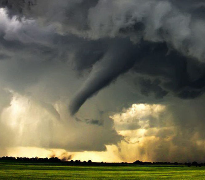
The weather service reported at 11 p.m. Sunday that all the warnings had expired and there were no confirmed reports of tornadoes touching down. But a video provided via Facebook to the Idaho State Journal by a local resident appears to show a twister on the ground.
We’re trying to contact the resident to confirm the location of the tornado and to find out for sure that it did touch down.
The weather service issued five tornado warnings in East Idaho on Sunday — an unusually high number. Golf-ball sized hail was also reported in multiple locations.
The weather service said four of the tornado warnings were triggered by its Doppler radar picking up storms capable of producing twisters. These warnings occurred at 8:17 p.m. near Blackfoot Reservoir, at 7:56 p.m. over Lava Hot Springs, and at 7:08 p.m. and 6:44 p.m. near Chesterfield and Chesterfield Reservoir in Caribou County.
The first tornado warning occurred at 5:09 p.m. when weather service spotters reported seeing a funnel cloud in the sky near Roberts in Jefferson County.
The weather service took the tornado threat so seriously that some of its tornado warnings ordered people to “take cover now” and provided instructions for motorists caught on roadways in a twister’s path. Anyone who spotted a twister was encouraged to contact the weather service’s office at Pocatello Regional Airport or the nearest law enforcement agency.
The weather service said after issuing its first tornado warning for the funnel cloud near Roberts that the incoming thunderstorms expected to hit East Idaho Sunday night might also have tornado potential — and this was proven true when the four later tornado warnings were issued.
The weather service offered the following advice Sunday evening to anyone in an area where a tornado warning was declared: “Take cover now. Move to a basement or an interior room on the lowest floor of a sturdy building. Avoid windows. If you are in a vehicle or outdoors, move to the closest substantial shelter and protect yourself from flying debris.”
In addition to the tornado warnings, the weather service reported that severe thunderstorms passed through the following counties Sunday afternoon and evening: Oneida, Power, Cassia, Bannock, Caribou, Bonneville, Bingham, Madison, Fremont, Clark, Teton and Jefferson.
These thunderstorms packed frequent lightning, heavy rain, large hail and winds in excess of 60 mph — similar to what would be created by a tropical storm.
The weather service advised Eastern Idahoans caught in a thunderstorm’s path: “for your protection move to an interior room on the lowest floor of your home or business. Heavy rains flood roads quickly so do not drive into areas where water covers the road.”
The rain from the storms was expected to be heavy enough to cause flash flooding, but we received no reports of flooding Sunday afternoon or evening.
Despite the abundance of severe and tornadic thunderstorms battering East Idaho Sunday, the weather service said it received no reports of any storm-related damage.
By Journal Staff Oct 2, 2016
Photo by Idaho State Journal (file photo)