While Allen County’s tornado Aug. 24 certainly didn’t pack the most punch, it likely did record the highest wind of Indiana’s confirmed twisters that afternoon, according to National Weather Service reports.
A total of 10 twisters occurred in Indiana during a series of storms Aug. 24, according to the weather service’s northern office in Syracuse, which has issued a final report. Six hit the central part with the other four the northeast. Two struck Kokomo in Grant County in central Indiana, one with a maximum wind speed of 75 mph and the other of 152 mph, according to a preliminary report from the Indianapolis office. The storms damaged at least 1,000 structures and destroyed 200, including flattening a Starbucks where several people had sought shelter, according to media reports. No fatalities and only one minor injury were reported for the northern Indiana forecast office. Another 11 moved across Ohio, 10 of those striking the northwest.
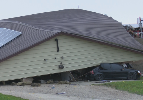
Woodburn’s tornado packed a maximum wind speed of 160 mph, actually more than Kokomo’s, both earning EF3 status. Tornadoes are rated on their wind strength, starting with the weakest at EF0. EF2 and EF3 twisters are considered strong. Unlike Kokomo’s, which caused significant structural damage to homes and businesses across the south side of the city, Allen County’s went through a rural area. The weather service reports that it gave people in the path of the Woodburn area tornado 13-25 minutes’ notice as part of 26 tornado warnings it issued.
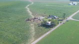
Woodburn’s tornado traveled 5.66 miles, with a maximum width of 500 yards. It spent roughly 11 minutes on the ground between 5:27 and 5:39 p.m. It took some days for a weather service survey crew to compile the storm damage because not all of it could be seen from the ground, said Michael Lewis, warning coordination meteorologist at National Weather Service.
An aerial exam was made, and spotters and others with drones have contributed photos to the weather service’s website, with more likely to come, he said.
The tornado destroyed five homes and two barns and damaged eight other homes and a barn, according to the Indiana Department of Homeland Security.
The region’s troubles began in Wells County with an EF0 tornado touching down for 0.04 mile 4:59-5 p.m. on County Road West 900 South, a half-mile east of South 1100 West. The next one hit 3.7 miles northwest of Woodburn and ended 4.1 miles east of Harlan. Another one struck at 5:49 p.m. 3.5 miles northwest of Berne in Adams County. The EF1 traveled 7.62 miles with winds up to 100 mph. The funnel cloud touched down several times over 11 minutes in bean and corn fields and ripped off roofs from several barns. Twisters next struck in Ohio, first in Paulding and Defiance counties then in Van Wert, which recorded four of them, and Miami, Defiance, Putnam and Henry counties 5:53-7:50 p.m.
Why did so many tornadoes occur? The weather service blames it on a combination of extreme low-level moisture and a passing upper-level disturbance. Tornadoes need moisture, instability and triggers that create lift, according to the weather service’s website. “Even though the clouds remained in place for most of the day and it did not get very warm, there was just enough instability to allow storms to develop,” according to the weather service. The disturbances created wind shear – changes in wind speed or direction – in the lower atmosphere that created rotation and spawned the tornadoes.
By Lisa M. Esquivel Long, August 30, 2016 6:16 PM
Photo by Scott Jordan “This image taken with the use of a drone shows tornado damage near Roberts and Doty roads in Woodburn.”