JACKSONVILLE, Fla. – The National Weather Service released new graphics illustrating its findings from a storm survey conducted Tuesday in the Crystal Springs area, WJXT reports.
Earlier on Tuesday, the NWS confirmed an EF-1 tornado touched down in the neighborhood on Jacksonville’s Westside Monday afternoon.
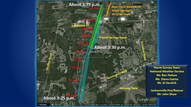
The images show the track of the tornado as it made its way through a few neighborhoods with a peak intensity of 100 mph. The NWS estimates the tornado touched down at 3:25 p.m. and stayed on land for about 10 minutes.
The light blue on the images represents EF-0 intensity and light green represents EF-1 intensity. The orange shows where the downdraft of the tornado touched the ground as the tornado was dissipating.
By News4Jax.com Staff
Posted: 8:45 PM, June 07, 2016
Updated: 8:19 AM, June 08, 2016
Copyright 2016 by WKMG ClickOrlando – All rights reserved.
Photo: WKMG ClickOrlando