OKLAHOMA CITY –
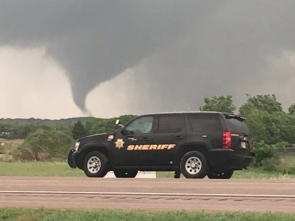
8:30 p.m. A tornado has touched down on the ground a few miles northwest of Woodward. A tornado warning was issued about 7:50 p.m. in Woodward County and was extended until 9:15 p.m. A tornado warning was shortly after 8:55 p.m. issued for Ellis County until 9:30 p.m.
The storm moving slowly to the east but the News 9 weather team said the tornado was almost stationary.
A tornado watch was issued for western Oklahoma counties until 10 p.m.
4:40 p.m. Storms forming ahead of the dryline in the Texas and Oklahoma panhandles are moving east toward Oklahoma.
The chance for storms remains greater in western Oklahoma and lessens quite a bit as you move east. There is only a slight chance storms make it to the western sides of the metro Monday night.
There is a slight chance of storms in the Oklahoma City metro late Monday night with higher chances staying in southern Oklahoma.
Temperatures only drop to the upper 60s overnight.
The dryline sets up out west again Tuesday. There is only a slight chance of storms in central Oklahoma Tuesday afternoon with higher chances northeast, east and southern Oklahoma. Skies stay mostly cloudy with highs in the mid-80s Tuesday.
Posted: May 23, 2016 5:37 PM EST Updated: May 23, 2016 10:04 PM EST
By Cassie Heiter, News 9 Weather
Picture:
potato 3
@nickurrrr