May 3, 1999, is forever burned into the memory of Oklahomans, thanks to one of the most infamous tornadoes in U.S. history.
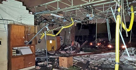
An F5 tornado tore through the cities of Bridge Creek, Newcastle, Moore and parts of the south side of Oklahoma City. It claimed 36 lives, destroyed 1,800 homes and damaged another 2,500, according to the National Weather Service.
The Doppler on Wheels research radar measured a wind speed of 301 mph about 100 feet above the ground in that tornado, which was up to three-quarters of a mile wide.
This single tornado, one of a Sooner State record 61 tornadoes during that May 3 outbreak, was the first F5 tornado on record to hit the Oklahoma City metro area.
Sadly, it wouldn’t be the last.
That 1999 outbreak was followed by seven more days with at least one F/EF3 or stronger tornado in the Oklahoma City metro area through 2015. Some of these stronger tornadoes hit almost the exact same areas as that original May 3, F5 tornado.
Including May 3, 1999, there have been 43 tornadoes in the Oklahoma City metro area through 2015, an average of two to three tornadoes each year.
As is the case with tornadoes in the U.S., the small fraction of violent tornadoes (six EF4, EF5 since May 3, 1999) were by far the deadliest and most destructive.
This was the first time in recorded history the Oklahoma City metro area was hit by F/EF3+ or stronger tornadoes on consecutive days.
There were only two tornadoes in central Oklahoma on May 8, 2003. Unfortunately, one of those was an F4 tornado that tracked over some of the same areas heavily damaged by the more infamous May 3, 1999 tornado in Moore and the south Oklahoma City metro area.
In another testament to the collaboration between NWS forecasters, local media, and the emergency management community, no fatalities occurred with this tornado.
What was also exceptional about this event was the following day.
Three more tornadoes were spawned in the Oklahoma City metro area the evening of May 9, 2003, including an F3 tornado tracking from south of Edmond to near Luther, Oklahoma, a path of 18 miles.
May 19-20, 2013 became the second time in recorded history to witness F/EF3+ tornadoes on consecutive days, almost exactly ten years after it was first done.
In fact, both the 2013 and 2003 events featured two tornadoes tracking from roughly the Edmond area to near Luther, as well as a Moore-to-Norman track.
May 10, 2010
This particular date doesn’t necessarily have the notorious cachet of other events, however, this was the second largest outbreak in recorded state history.
A total of 56 tornadoes were observed in Oklahoma that afternoon.
Two of these tornadoes were rated EF4, and another four were rated EF3 on the Enhanced Fujita scale. According to NWS-Norman, over a roughly two-and-a-half hour period, there was at least one tornado taking place each minute somewhere in the Sooner State.
One of those EF4 tornadoes carved through the north side of Norman and southeast side of Moore, along its 24-mile-long path. Two were killed and 49 injured from this tornado.
Amazingly, two other tornadoes also touched down in Moore that day, both rated EF1. One of those took a four-mile path in the east side of the city of Moore.
May 24, 2011
One of roughly 51 tornadoes that day in the Plains, an EF4 tornado in Grady and McClain Counties thankfully weakened substantially before moving into the southwest side of the Oklahoma City metro area, with only minor tree and power line damage, according to the National Weather Service.
Perhaps the most infamous tornado that day, however, was an EF5 tornado that levelled areas just to the northwest of the Oklahoma City metro area, including parts of El Reno, Piedmont, and Guthrie, Oklahoma.
With over 130 additional tornadoes the following two days, this May 24-26, 2011 outbreak became one of the nation’s worst on record, based on the combination of statistics compiled by The Weather Channel severe weather expert, Dr. Greg Forbes.
May 19-20, 2013
Destructive tornadoes on back-to-back days raked through parts of central Oklahoma in mid-late May 2013.
On the evening of May 19, an EF4 tornado tracked from Lake Thunderbird on the east side of the city of Norman to near Shawnee, Oklahoma. Another EF3 tornado tracked from far northeast Oklahoma County into Logan and Lincoln Counties, including the towns of Carney, and Luther. Before spawning that tornado, an EF1 tornado was spawned in the northern suburb of Edmond.
As residents were sifting through the debris from these tornadoes the following day, a lone supercell thunderstorm spawned a massive EF5 tornado up to 1.3 miles wide through Newcastle and Moore, Oklahoma, claiming 24 lives. Two schools were levelled and the Moore Medical Center was heavily damaged. Over 300 homes suffered EF4 or EF5 damage, according to NWS-Norman.
Damage estimates from this single tornado on May 20 were about $2 billion.
May 31, 2013
Of the 11 tornadoes in Oklahoma, Cleveland or Canadian Counties that day, an exceptionally wide, intense, multi-vortex tornado near El Reno, Oklahoma, was the headliner of the outbreak.
The El Reno tornado claimed eight lives, all in vehicles, including renowned storm chaser/researcher Tim Samaras, his son Paul, and his chase partner Carl Young. The circulation also overtook and rolled The Weather Channel’s Tornado Hunt vehicle, requiring one chase team member to be hospitalized.
The University of Oklahoma’s RaXPol mobile radar sampled winds of at least 295 mph in the El Reno tornado. The Doppler on Wheels mobile radar from the Center for Severe Weather Research also measured winds over 200 mph. Initially rated an EF5 tornado based on these measurements, NOAA then downgraded the rating to EF3 in late August 2013, since the Enhanced-Fujita is a tornado damage scale, and no damage higher than EF3 was found.
The width of the tornado was given a conservative estimate of 2.6 miles, a new official record for the widest U.S. tornado, beating the previous record of 2.5 miles near Hallam, Nebraska, on May 22, 2004.
There were several vortices wrapping around the massive circulation of the El Reno tornado.
“Think of the average size of an Oklahoma tornado you’d see on a typical afternoon. Three or four of those things moving along the ground at a speed of 170 to 180 mph, crossing each other with all kinds of violent motions going on,” said Rick Smith, warning coordination meteorologist at the National Weather Service in Norman, Oklahoma. “So this is going to be studied for a long time.”
Smith later noted that a few of these vortices may have been moving along the ground at a jaw-dropping forward speed of 185 mph, even as the parent tornado lumbered along at a forward speed of about 24 mph.
Smith noted that the extreme winds associated with the subvortices affected a relatively small area compared to the tornado as a whole. None of the subvortices hit any structures, which is why mobile radar data from the University of Oklahoma were needed to assess the true strength of tornado; based on damage alone, survey crews could only find visual evidence of EF3 winds.
Amazingly, the Doppler on Wheels also detected an EF2 tornado rotating anticyclonically (winds rotating clockwise, instead of counterclockwise, as in most northern hemisphere tornadoes) southeast of the main El Reno tornado.
The tornadic supercells then rolled into the Oklahoma City metro area during Friday evening rush. In a word, it was “chaos.” Passengers at Will Rogers World Airport were evacuated to underground tunnels. Freeways, including Interstate 35, were jammed with traffic.
An EF1 tornado was confirmed to have tracked 10.4 miles across the southwest Oklahoma City metro, including Will Rogers World Airport. Another EF0 tornado touched down on the north side of Moore.
If that wasn’t enough, training thunderstorms moving across the metro area triggered deadly flash flooding that evening. In Oklahoma County, 13 people lost their lives in the flash flood. At least 23 high water rescues were conducted.
May 6, 2015
Once again, just days from the May 3, 1999 anniversary, a Plains tornado outbreak included the Oklahoma City metro area.
An EF3 tornado tore a two-mile swath through the city’s southeast side, heavily damaging a hotel and an RV park, injuring 12.
Earlier that afternoon, in another case of 1999 deja vu, a separate EF3 tornado tore through parts of Bridge Creek, Oklahoma, damaging dozens of homes.
An EF1 tornado damaged roofs, trees, fences, and power poles on the northwest side of Norman, Oklahoma, as well.
People inside Oklahoma City’s Will Rogers World Airport were told to take shelter in storm shelter tunnels twice due to the tornado threat.
In all, about 56 tornadoes touched down in four states that day, according to The Weather Channel severe weather expert Dr. Greg Forbes.
Sadly, while the tornadoes weren’t directly responsible for any fatalities, record daily rainfall for the month of May claimed the life of a woman seeking shelter from the tornado in an underground storm cellar.
Oklahoma City’s Long Tornadic History
Thanks to considerable effort from the National Weather Service (NWS) office in Norman, Oklahoma, NOAA’s Storm Prediction Center and historical tornado guru Tom Grazulis, this long history has been documented as best as records allow.
From 1890-2015, at least 160 tornadoes were documented in the Oklahoma City metro area, an average of just over one each year. Since weak tornadoes were not always documented prior to 1950, this number is likely well underestimated, according to NWS.
Some other interesting facts from the NWS/SPC/Grazulis study:
13 violent tornadoes (F/EF4 or stronger) occurred, including May 19, 2013 in Shawnee and May 20, 2013 in Moore.
May is the peak month, followed by April and June. About two-thirds of all metro tornadoes have occurred in those months.
Mid-afternoon through early evening is the most frequent time of day.
Through 2015, the OKC metro experienced two or more tornadoes on the same day 27 separate times.
Only three periods since 1950 had over a two-year lapse between tornadoes.
It was a pair of Oklahoma City metro tornadoes that helped launch the very severe weather forecasts that we depend on today.
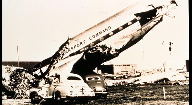
On March 20, 1948, an F3 tornado demolished 52 aircraft at Tinker Air Force Base on Oklahoma City’s southeast side. At the time, it was the costliest tornado in state history.
The following day, the Tinker Base Weather Station was directed to investigate whether this type of event could be predicted. Prior to this time, public tornado alerts were banned from the late 1880s until 1938, for fear of causing “unneeded panic.”
In charge of this effort were Major Ernest Fawbush and Captain Robert Miller.
Analyzing several other recent outbreaks, Fawbush and Miller noticed large-scale weather patterns common to each event.
On the morning of March 25, 1948, Fawbush and Miller found a similar weather pattern setting up that day, concluding a threat of tornadoes existed again in central Oklahoma that afternoon.
After consulting Commanding General of the Oklahoma City Air Material Area, Fred Borum, a forecast for “heavy thunderstorms between 5 and 6 p.m.” was issued for the base.
As it turned out, thunderstorms did form west of the Oklahoma City metro area in mid-afternoon. The forecast time of arrival: around 6 p.m. General Borum then asked, “Are you going to issue a tornado forecast?”
After some understandable queasiness, Fawbush and Miller issued what was probably the equivalent of today’s “tornado watch” for the base. Preparations raced to completion, including moving base personnel and moving aircraft to hangars.
Just after 6 p.m., a tornado had, in fact, touched down at Tinker AFB. The first operational tornado forecast was a rousing success.
While we still cannot forecast today exactly where, or sometimes if, tornadoes will track on any given day, the Fawbush and Miller forecast proved general conditions favorable for severe weather could be forecast ahead of time.
The fact we can pinpoint dangerous severe weather potential even a couple of days out today can be traced back to this courageous forecast in 1948 and the subsequent development of forecast techniques and Doppler radar by talented research and operational meteorologists.