Wednesday’s weather is expected to be a drastic change for the better after a solid band of thunderstorms steadily moved across Texas late Tuesday night.
One person was taken to a hospital in critical condition and four others were injured from storms in Grayson County, about 70 miles north of Dallas. There were at least three tornadoes, according to the National Weather Service. The second and third were confirmed Wednesday afternoon after crews surveyed the area.
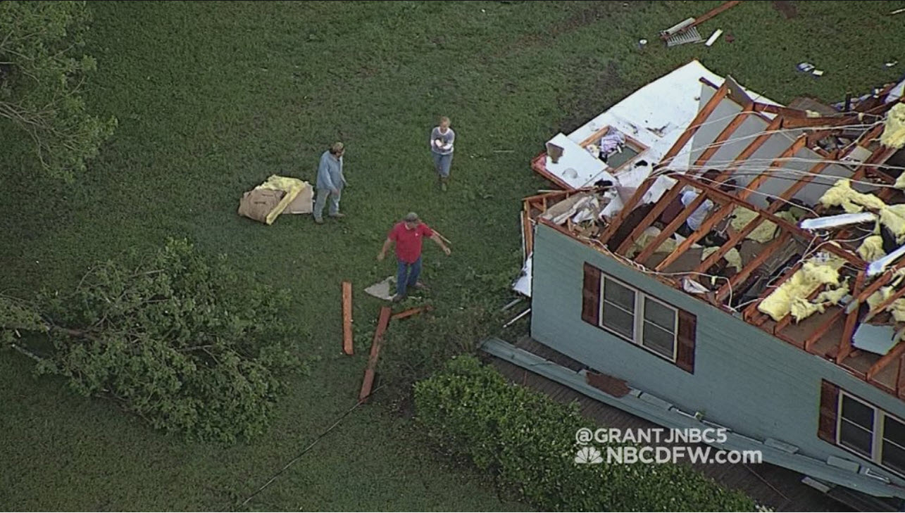
The dangerous weather caught Kent Clemens and his wife by surprise. They had just returned to their home outside Sherman from a trip to Mexico and were taking shelter when the power went out and Clemens felt his ears pop.
“I knew at that time, when I felt the pressure, that there was a tornado,” he said. “There were trees coming through the roof. … It was raining inside.”
Clemens home was badly damaged, but he and his wife safely rode out the storm in a bathroom. Their animals, too, were safe.
The tornado watch issued for much of North Texas expired at midnight, said meteorologist Jesse Moore with the National Weather Service.
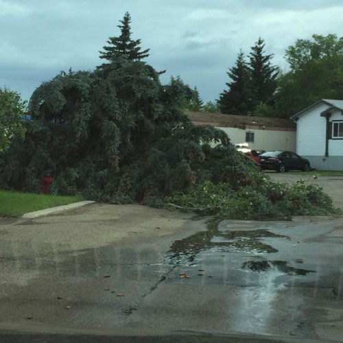
The storms reached downtown Dallas about 10:30 p.m. bringing with them heavy rain and a light show. Wind gusts up to 40 to 50 mph were also reported. Most areas received less than two inches of rain so there wasn’t much flash flooding.
The band of storms continued moving about 40 mph and headed into southeast Texas and Louisiana early Wednesday morning.
As for Wednesday’s forecast: “Tomorrow looks beautiful,” Fano said Tuesday night.
Clouds dotting the skies Wednesday morning are expected to move to the east as the sun breaks through with highs in the mid 80s, Moore said. If you think the last few days have been humid, then he said to prepare for another muggy day.
Flooding, damage, observations
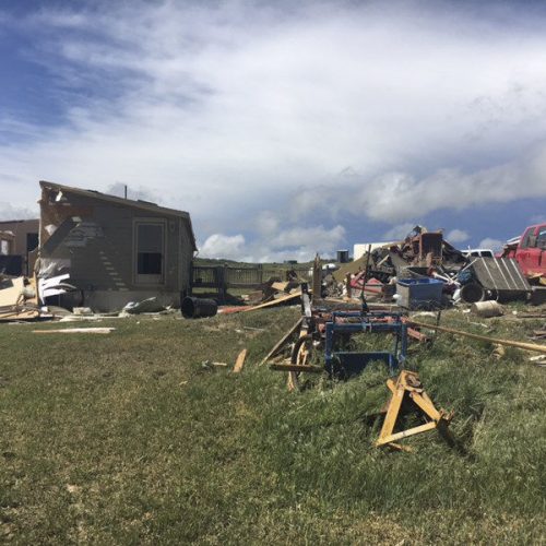
The weather service confirmed three tornadoes touched down in Grayson County on Tuesday night.
An EF-0 tornado with wind speeds between 80 and 85 mph was confirmed in Bells, near Sherman. The tornado touched down at 10:08 p.m. and traveled six miles. It had the longest path of the three tornadoes and damaged roofs and several barns and farm buildings.
An EF-1 tornado tore through Howe at 10 p.m., about 20 miles west of Bells along U.S. 75., tearing the roofs off too homes and downing power lines.
A third tornado was confirmed Wednesday afternoon. The EF-1 tornado with peak wind speeds up to 90 mph hit Whitesboro at 9:22 p.m. and lasted a minute. But for the shortest twister it produced the strongest damage. The tornado blew off a portion of the roof of a house and threw it into a nearby business. As many as 15 homes were also damaged.
Several schools are closed as cleanup begins and crews work to return power to areas that lost it in the storms. The Collin County courthouse is running on auxiliary power and there’s not an estimate on when power will be restored, according to a county Facebook post. The administration building does have power, though, so the county clerk and tax assessor offices are open.
A 90 mph wind gust was reported in Sherman at 10:13 p.m., according to the National Weather Service.
In Frisco, a family and their pets managed to escape after a fire started at their home in the 15200 block of Nottingham Lane, (NBC5) reported.
Investigators will determine what caused the fire, but neighbors reported seeing a bolt of lightning strike the home followed by flames coming from the roof, NBC5 reported.
It’s unclear whether lightning caused the fire.
And in Denton, the storm complicated matters as firefighters worked to put out a fire at a building in the 2800 block of Airport Road in Denton, the Denton Record-Chronicle reported.
There were other reports of fires most likely caused by lightning strikes, including Plano, Kaufman County, Irving and another in Frisco.
Nickel-sized hail was reported in Garland.
“We were lucky,” Moore said. “We did not have extremely large hail.”
NBC5 meteorologist Brian James reported that at 10:13 p.m., more than 3,000 lightning strikes were recorded in 15 minutes.
Localized flooding has been reported in Denton and there is some pooling of water in downtown Fort Worth near Sundance Square where the storm passed over shortly after 10 p.m.
Winds up to 60 mph and hail up to 1 inch were reported in some places at the storm headed east toward Dallas-Fort Worth, the weather service reported.
How to help
Those interested in donating to help the hardest hit area in Tuesday’s storms can contact the United Way of Grayson County.
By phone: 903-893-1920
By mail: PO Box 1112 Sherman, TX 75092
Checks should be made payable to United Way of Grayson County c/o GD Relief
By CLAIRE Z. CARDONA, LIZ FARMER and TOM STEELE
Staff Writers