The trail of damage left behind by tornadoes that tore through the Kansas City area Tuesday night will be investigated by survey teams from the National Weather Service offices in Topeka and Pleasant Hill.
The teams left early Wednesday morning to survey the area where the storms passed through, and will work toward measuring the total damage path lane and width, along with assigning EF-scale grades to the tornadoes, said Jonathan Kurtz, a meteorologist with the weather service in Pleasant Hill. Results likely will not be available until Wednesday afternoon at the earliest.
“We did have at least two tornadoes,” Kurtz said. “Both were associated with the same storms.”
One touched down on the Kansas side, in the southwest corner of Douglas County, and spun its way up past Lawrence and Linwood toward Bonner Springs in the Kansas City metropolitan area.
The second tornado touched down in Missouri near Kearney in Clay County and moved toward Excelsior Springs.
“A second tornado hasn’t been ruled out (in Missouri),” Kurtz said. “Our survey crews will take a look. We may have that third possible tornado, but right now we haven’t received much information yet from emergency management up there if there was any damage associated with that other circulation.”
There were no deaths reported from the tornadoes. There were 15 weather-related injuries, three of which were serious, in Douglas County.
On Wednesday, U.S. Sen. Pat Roberts, a Kansas Republican, called for seven Kansas counties affected by the tornadoes to receive federal disaster aid and asked the White House to expedite the state’s request. President Donald Trump approved disaster declarations for 18 Kansas counties earlier in the week because of severe flooding, but Gov. Laura Kelly has made emergency declarations for 56 counties, including the seven affected by tornadoes.
Tuesday’s tornadoes developed along a warm front that was hovering over the Kansas City metropolitan area and laying east and west across the region, Kurtz said.
“Once these storms got anchored on that boundary, they just kind of rode right along it,” he said.
Kurtz estimated that the tornado was on the ground for 40 or 50 miles. The survey crews will determine how long the path actually was.
“A tornado this size and length will take quite a while for us to wrap our hands around what exactly happened and get more details,” Kurtz said. “As more concrete details come out, we will be sure to share them.”
The results will be released on Twitter because of high interest in the tornadoes, he said. There was no preliminary estimate on the strength of the tornadoes.
The tornado that slammed into rural portions of Douglas County began to develop about 5:30 p.m. in Neosho Rapids, about 100 miles southwest of Kansas City. The storm then tracked up through Osage County into Douglas County.
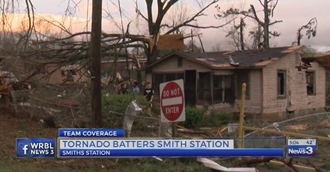
The most significant damage was south and east of Lawrence, said Bill Gargan, a meteorologist with the National Weather Service office in Topeka.
“We had very good lead time on this tornado,” Gargan said. “Luckily, it did seem like people did take the warning seriously, especially the tornado emergency that we issued.”
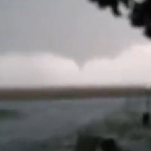
Unlike some others, the tornado on Tuesday was less visible, a kind of rain-wrapped tornado for its entire life cycle, obscured by the rain shaft, Gargan said.
“If you were trying to look for it you wouldn’t have seen it,” Gargan said. “We advise people never to go out and look.”
Weather officials issued a tornado emergency for Lawrence and points southeast and east of Lawrence.
There are reports of damage near Clinton Lake and just southeast of Lawrence, and on the north side of Eudora. The tornado was probably on the ground for that length, Gargan said.
The tornado maintained a constant speed as it traveled northeast at about 30 mph. The average tornado speed is usually between 25 to 30 mph range.
The tornado moved out of Kansas and traveled into Clay County in northern portion of Kansas City at about 7 p.m.
“We saw this coming a few days before it happened that there could be tornadoes through our entire county warning forecast area,” Gargan said.
The storms also brought heavy rains to the area, which created flash flooding and exacerbated river flooding.
“Although the tornadoes are the most eye-catching severe weather we have, these storms developed a lot of heavy rainfall across parts of northern Missouri,” Kurtz said. “That just dumped a bunch of rain. We had rainfall amounts of over 5 inches in the last 24 hours in some places in northern Missouri.”
More people have been impacted by flooding so far than by tornadoes and other types of severe weather like hail and wind, Kurtz said.
by Robert A. Cronkleton, Katie Bernard, Glenn E. Rice, and Nicole Asbury (2019, May 29 | Updated 2019, May 30) The Kansas City Star