Is Howard County the new tornado alley? On Thursday afternoon, for the second time in a week, a tornado touched down in the county, snapping, stripping and toppling trees while damaging buildings.
The twister was spawned by a supercell thunderstorm that also produced a second tornado in Frederick County.
Thursday’s tornado in Howard County’s Glenelg, about 11 miles west of Ellicott City, came exactly one week after the Weather Service confirmed that an EF1-rated twister touched down between Clarksville and Columbia on May 23 around 3:30 p.m.
The Glenelg tornado was on the ground between 3:20 and 3:27 p.m., just five or so miles away from the one the week before. The Weather Service said it received video evidence of the twister while weather radar revealed both storm rotation and debris in the air.
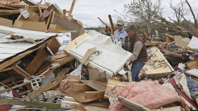
The Weather Service’s storm survey, released Friday evening, indicated the storm carved a 4.5 mile path on the south side of Glenelg, and was as wide as 100 yards. The twister’s peak winds were estimated at 100 mph and it was rated an EF-1 on the 0 to 5 scale for intensity.
Damage reports submitted to the Weather Service documented tree and roof damage in Glenelg and multiple trees down in a neighborhood just west of Ellicott City, including one on top of a home, where the tornado may have tracked.
Additionally, we received social media video of toppled and stripped trees on MD-32 southwest of Ellicott City.
The same supercell responsible for the Howard County tornado had previously spawned an EF-0 tornado near Ijamsville in Frederick County, the Weather Service determined. That weak tornado was sporadically on the ground for 6.5 miles between 2:48 and 2:59 p.m. It was as wide as 75 yards and produced winds up to 85 mph, strong enough to cause patches of downed trees. In New Market, just to the west of Ijamsville, winds were clocked up to 71 mph.
Two additional supercell storms tore through the Washington region Thursday, one that may have spawned yet another tornado in Spotsylvania County while the other left behind a trail of tree damage through northern Prince William and southern Fairfax County.
Supercells are rotating thunderstorms, which sometimes unleash twisters but can produce straight-line wind damage as well.
The northernmost supercell tracked from Frederick to Baltimore along and just south of Interstate 70, spawning the Ijamsville and Glenelg tornadoes.
The middle supercell tracked from near The Plains in northern Fauquier County, through Gainesville where a 71 mph wind gust was reported, and then east through Mount Vernon, where we received photos of downed trees.
The southernmost supercell tracked from Orange and Culpeper counties through Spotsylvania County, south of Fredericksburg, into King George County. The Weather Service said a trained storm spotter reported a tornado over Massaponax, seven miles south of Fredericksburg, but has not yet verified that report.
While storms zipped across the Beltway in two waves Thursday afternoon and evening, they were mostly subsevere and more intense to the north and south. Even so, Reagan National Airport reported a wind gust to 52 mph with the initial wave.
Howard County tornado in more detail
The tornado that struck Columbia a week ago was produced by a small circulation (called a mesovortex) embedded in a wavy, squall-line of thunderstorms called a quasi-linear convective system (QLCS).
This week’s Glenelg tornado was not part of an extensive line but, rather, a more isolated storm with supercell attributes. These storms have deeper, more intense mesocyclones, which are regions of rotation. The mesocyclone “fed” off the spin energy contained in winds that increased sharply with altitude (wind shear).
Doppler radar is a first-line tool for identifying mesocyclones, as long as the storm is not a great distance from the radar. There are several attributes of supercells that herald these circulations, and thus the possibility of a tornado. Although, note that only about 25 percent of mesocyclones further concentrate their spin into the much smaller, vertical vortex we call a tornado.
Based on preliminary data, the National Weather Service stated the tornado touched down at 3:22 p.m.
The tornado cannot be resolved by the Doppler, due to the distance from the radar, and its very small size. Furthermore, many weak tornadoes form and dissipate within the time frame of successive Doppler images, which is about 5 minutes. This makes them very difficult to warn for, but the Weather Service did issue a warning at 3:22 p.m. right around the time this tornado appeared to form.
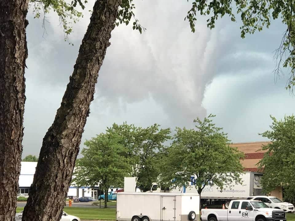
On social media, we viewed many menacing photos of the supercell storms in both Howard and Spotsylvania counties. None of them conclusively show the tornado, but do reveal the spin in the atmosphere…
by Jason Samenow and Jeff Halverson (2019, May 31) The Washington Post