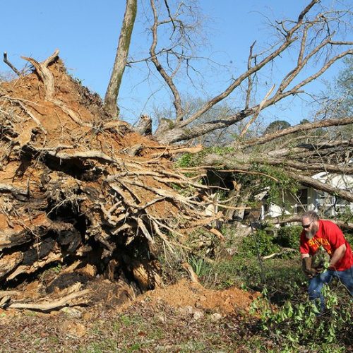
Severe storms have plagued parts of the Plains since Friday, including about 50 reported tornadoes, and more severe weather is on the way. A dangerous severe weather outbreak is possible Monday, which would target parts of Oklahoma, Kansas and Texas. Massive hail, destructive winds, and potentially strong tornadoes could be in the offing.
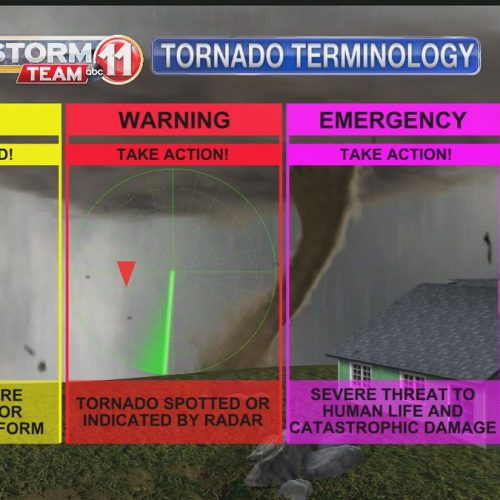
On Saturday, the National Weather Service Storm Prediction Center (SPC) raised the severe weather threat to its second-highest level (4 out of 5) on Monday. That’s a surefire sign confidence is high for a potentially significant event. Since 2003, only 18 events have prompted SPC to raise a red flag that early.
The potential outbreak stems from the overlap of plentiful instability and loads of wind shear — a change of wind speed or direction with height. Roaring jet stream winds of more than 120 mph, just 17,000 feet above the ground, will only make the storms stronger, setting them rotating like a spinning top.
In events with as much storm “fuel” as this, so many storms can develop that they merge and compete, limiting the tornado risk. That doesn’t look to be the case Monday. The National Weather Service is forecasting wind profiles “very favorable for discrete supercells capable of all severe hazards, including significant tornadoes.”
Much of the day will be storm-free, with the threat peaking late in the afternoon hours as sunlight bakes the ground. By suppertime, storms will fire along a dryline in the Texas and Oklahoma panhandles. That’s where dry desert air meets the oppressively muggy winds streaming north from the Gulf of Mexico. The resulting clash can produce vicious storms that tower more than 10 miles high. It’s beautiful, spectacular, and deadly.
Oklahoma City is in the bull’s eye, as is Moore — the southern suburb that saw neighborhoods razed by EF5 tornadoes in both 1999 and 2013. Monday marks exactly six years since the infamous May 20, 2013, tornado in which 24 people died, an eerie coincidence as the same location could be affected by dangerous weather again.
The first storms may bubble up around the late afternoon hours in western areas, trekking east and approaching Interstate 35 around or just before sunset. These are the supercells that could feature hail as large as softballs, winds topping 80 mph and higher-end tornadoes. A second line could develop Monday evening into the overnight, favored to be a line of storms with damaging winds as the primary threat.
More than 50 reports of tornadoes since Friday in the Plains
The same areas forecast to see severe weather Monday saw a nasty batch of storms Saturday morning. Thirteen tornadoes were reported from Central Texas to Oklahoma, including damaging twisters in both Abilene and San Angelo, Tex.
On Friday, several photogenic tornadoes touched down in western Nebraska and Kansas, prompting more than 150 reports of severe weather, including 39 tornadoes. Hardest hit was a corridor from McCook to Culbertson, Neb., where a single supercell storm dropped up to half a dozen tornadoes as other storms eventually merged with it. Farther south, a long-track supercell produced what was probably a significant tornado east of Dodge City, Kan., after dark.
Even after Monday’s storms exit, the Plains are far from done. Another episode of severe weather is possible Wednesday into Thursday.
You don’t take any chances in May in Tornado Alley.
by Matthew Cappucci (2019, May 18) The Washington Post