Rotating supercell thunderstorms barreled across the North Carolina Piedmont on Saturday night, prompting tornado sirens to blare in Charlotte as three dangerous storms targeted the city. A total of 18 tornado warnings were issued for the trio of tempests as they straddled the North Carolina-South Carolina State line and tracked directly into the Queen City shortly after 9:30 p.m.
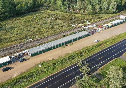
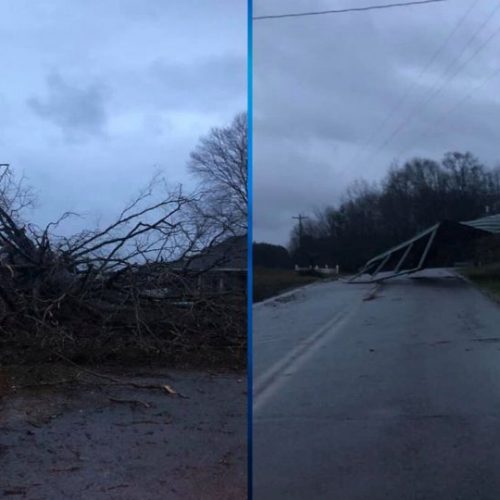
In the end, only one tornado touched down in Taylors, S.C. —— some 85 miles from Charlotte. That twister peeled the roof off a motel and tossed trees on top of cars. But otherwise, no twisters formed along the 150-mile path of tornado warnings that blanketed the storms’ paths.
Issuing tornado warnings is challenging on a good day, but in the Charlotte area, it’s especially difficult. That’s because the metro area of 2.5 million people occupies one of the most infamous weather radar “gaps” in the country.
Mind the gap
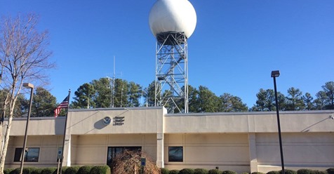
The nearest Doppler radar facility owned by the National Weather Service is located more than 80 miles to the west-southwest of Charlotte. It was moved out of the city in 1996 and is in Greer, S.C.
Until late 2019, that radar didn’t scan most of the Charlotte skies below 7,245 feet elevation — making it virtually impossible for meteorologists, with that radar, to discern reliably what was happening closer to the ground.
Other National Weather Service radars, like those in Raleigh and Columbia, S.C., are even farther away.
A problem for forecasters
A radar’s detection beam leaves the dome at an angle; that, coupled with the Earth’s curvature, means the farther one gets from the radar, the higher in the sky the beam scans.
That poses an immense challenge to forecasters worried about the weather in Charlotte, since the radar beam incessantly “overshoots” the most important part of storms — the region closest to the ground.
That’s been a problem for years, undermining forecasters’ confidence by limiting the tools they have at their disposal. In the case of Saturday night’s storms, radar revealed strong rotation in the mid-levels of the storm — but there was no way for the Greer-based radar apparatus to determine if that spin snaked closer to the ground.
Efforts at a fix
In early 2019, a proposal was written up to lower the minimum beam angle for the Greer radar among others. That allows the radar to “see” down to a little under 5,000 feet over Charlotte, but it’s still a Band-Aid solution at best — not improving the radar’s resolution or power over the city.
Meteorologists are routinely forced to rely on “TCLT,” a smaller, lower-power “terminal” Doppler radar located at Charlotte Douglas International Airport. It scans the skies at as low as 400 feet over Charlotte.
The only problem? Its signal wavelength is only about half as long, which is good for resolution — but bad for attenuation. That describes the reduction of a signal as it travels through a medium like rain or snow.
On Saturday night, the presence of three supercells all lined up rendered many scans of the radar virtually unusable. Nate Johnson, a veteran North Carolina meteorologist, referred to the data as “inconsistently helpful at best.”
Moreover, a wedge of data from the terminal Doppler radar is missing from each scan, since the signal is shut off when facing north-northwest so as not to interfere with a communications tower.
“We rely very heavily on that area on the [terminal Doppler radar],” said Lauren Carroll, a meteorologist at the National Weather Service office in Greenville-Spartanburg, S.C.
Congressional efforts have yet to deliver
No other major East Coast city has a radar coverage as poor as Charlotte. It’s an issue that has even captured the attention of legislators following an unwarned tornado that struck the city in 2012.
The issue of radar coverage gaps, including the blind spot when it comes to low level wind data over Charlotte, has led to a flurry of legislation in recent years. In 2015, North Carolina Sens. Richard Burr (R) and Thom Tillis (R), among others, introduced a bill to require the National Weather Service to have a Doppler radar in place within 55 miles of any city with a population of 700,000 or greater. This would include Charlotte, which is covered by a radar more than 80 miles away. Far eastern suburbs of Charlotte, like Mint Hill and Harrisburg, are up to 90 miles away from the radar. That bill passed the Senate but died in the House.
Another effort stalled during the 114th Congress, but a provision in the 2017 Weather Research and Forecasting Innovation Act, this time pushed by a bipartisan group of senators representing both the East and West coasts, calls for the National Weather Service to deliver a report to Congress detailing radar coverage gaps and propose plans on how to fill them.
The report was supposed to be completed within 120 days after the bill was signed into law, which took place in April 2017, but it still has not been produced. A spokesperson for the National Weather Service said it is still under development and review.
Meteorologists forced to take matters into their own hands
The holdup in Congress has left many television meteorologists seeking a public-private partnership to solve the issue.
“The Federal route took years to get a bill, and the outcome was just [three distant radars serving Charlotte] lowered their … tilts to 0.2 degrees,” wrote Brad Panovich, chief meteorologist at WCNC, Charlotte’s NBC affiliate, in an email. “That’s it.”
Panovich has spearheaded an effort alongside other meteorologists to secure better radar coverage for Charlotte.
“There is a group of television meteorologists and private sector meteorologists who have been working together for over a decade on this issue,” Panovich wrote.
“We are currently working on the North Carolina Radar Project with local governments to place 3 C-band radars in the gap through a public/private partnership. The process has been painstakingly slow, but I feel like this is the closest we have been this whole time.”
According to Panovich, nearly 4.3 million — or 41 percent of the state’s population — lives within the “radar gap.” He says it’s contributed to undetected tornadoes and inflated false alarm rates — as with Saturday night’s event.
What’s next in the process remains to be seen, but Panovich said he hopes residents of the Triad take an active role in pushing the project forward.
“The next step is a public campaign to get local companies and the public involved, mainly to keep the pressure on the [council of governments],” he wrote. “This whole thing could be a book someday.”
by Matthew Cappucci and Andrew Freedman (2020, April 27) The Washington Post