AVON — What a difference a few miles makes.
The small community of Avon found that out Tuesday night, as residents living within the heart of the town experienced hail, thunderstorms and torrential rain. But there was more damage outside of town, as a tornado was reported roughly 5 miles south of Avon. That’s where property damage to a handful of residences and outbuildings was reported.
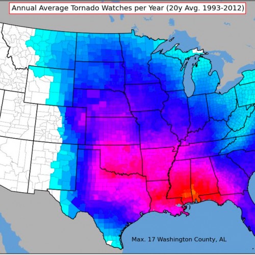
The National Weather Service office in Sioux Falls received a report of a brief tornado touchdown in the area at 8:13 p.m. Tuesday from trained weather spotter. Peter Rogers, a meteorologist with the NWS in Sioux Falls, said they were still looking further into the size and scale of the reported tornado and possible damage. The storm eventually resulted in three EF-2 tornadoes and 130 mph wind gusts in Sioux Falls, where dozens of buildings were damaged.
Elsewhere, dozens of southeastern South Dakota communities received more than 3 inches of rain on Tuesday night and Wednesday morning.
In all, the NWS office in Sioux Falls issued 12 tornado warnings throughout Tuesday night in southeastern South Dakota, ranging from Platte to Garretson. A brief tornado touchdown was reported 5 miles south of Avon around 8:15 p.m. on Tuesday, but no damage has been reported.
Warnings were also issued in Bon Homme, Charles Mix, Davison, Hutchinson, Lincoln, McCook and Minnehaha counties on Tuesday night, before a confirmed tornado was reported on the south edge of Sioux Falls at 11:25 p.m. Eight people reported minor injuries and nearly 40 structures were reported destroyed.
Emery had the region’s high for rainfall, reporting 5.54 inches of rain by 6 a.m. on Wednesday morning, while 4.67 inches of rain was reported near Montrose. Delmont, Parkston and Mount Vernon received at least 4.1 inches of rain, while Corsica received 3.85 inches, while White Lake, Avon, Pukwana, Burke and Gregory all received at least 3 inches of rain. Alexandria, Canova and Lake Andes received at least 2.75 inches of rain in the storm.
Mitchell officially received 2.52 inches of rain in the storm, including 2.41 inches of rain in the span of four hours and 1.72 inches of rain in an hour around 11 p.m. Tuesday night at the Mitchell Municipal Airport.
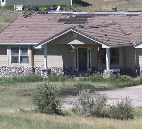
Mark Tolsma, owner of the Tolsma’s Cove bar in Avon, said heavy rain, small spouts of hail and moderate wind gusts were the elements he experienced throughout much of Tuesday night’s storm. While Tolsma’s home didn’t suffer any destruction, the tornado that touched down at around 8:15 p.m. inflicted serious damage to his nephew, Jeff Tolsma’s rural residence, which is situated on edge of Bon Homme County.
“All the shingles were ripped off his house, and the roof of his barn was almost completely torn off,” Tolsma said of his nephew’s residence. “We didn’t have that extreme of wind gusts in town, but it rained hard for a while.”
To paint a clearer picture of how strong the tornado’s wind gusts were, Julie Tolsma, Mark’s wife, said her nephew’s heavy pellet grill was lifted off the ground during the tornado. She too was shocked when she learned of a tornado touching down south of town.
“When that was all happening out there, it was pretty calm in town, which is crazy,” Julie Tolsma said Wednesday.
Julie Tolsma said the tornado sirens in Avon didn’t sound. The aftermath of the thunderstorm was a stark contrast from the outskirts of Avon, where there was mostly standing water in the community’s park. Rainfall totals reported to the National Weather Service said Avon received 1 inch of rain.
Brandon Kayser, a farmer who lives about 4 miles northeast of Avon, said the storm produced heavy wind gusts near his home. When he learned about the tornado touching down on Wednesday, he was shocked.
“It’s crazy how the tornado seemed to stay isolated in that area,” Kayser said. “I feel for the people who were hit by the tornado, but I haven’t heard about a tornado touching down for at least four to five years.”
Jamie Wren, a cashier at A-1 Gas and Go in Avon, commutes to work from her Dante home. She said the heavy wind and rain made for a nervous night throughout the area.
“The wind gusts were about 50 to 60 mph, but it was off and on raining until about 9:30 p.m. But it started back up around 10 p.m.,” Wren said Wednesday afternoon. “We were fortunate we didn’t see a tornado in Dante.”
Wet conditions fill region
Dave Hoffman, who serves as emergency manager for Hutchinson County and mayor of Parkston, said the city and county are dealing with excessive amounts of rain.
“Water. That’s all I can say,” Hoffman said.
The National Weather Service reported that 4.4 inches of rain fell near Parkston, though Hoffman said he had heard reports of as much as 5.5 to 8 inches of rain in various places throughout the county.
“We have sewers backed up (in Parkston), and so much water coming in from the outside,” Hoffman said.
Hoffman said there was water over the road in two locations on State Highway 37 near Parkston, as well as some spots on State Highway 44.
While tornado warning sirens were sounded in Hutchinson County communities, Hoffman said there was no apparent indication of a tornado. Storm spotters were dispatched throughout the county, he said.
The rain brought flooding to a county that has dealt with heavy precipitation throughout the summer. Some rural roads that had been repaired multiple times already during the summer were flooded again, making travel difficult and at times treacherous. The Parkston School District called off school Wednesday due to the poor conditions of rural roads. Hoffman also encouraged the public to use extreme caution when driving.
Hoffman said it’s been a difficult few months for storms, and he’s hoping the severe weather season is coming to an end soon.
“We can always wish for snow,” Hoffman said.
The situation was similar in McCook County, where B.J. Stiefvater, emergency manager for the county, said flooding was the primary concern after the storm, although the NWS did report winds as high as 60 miles per hour south of Canistota shortly before 11 p.m.
“The main thing is flooding. We didn’t have a whole lot of damage from winds,” Steifvater said. “It didn’t create a lot of damage, a few branches a twigs came down that were saturated.”
Stiefvater said there was water over the road in locations throughout the county, including a portion of U.S. Highway 81 just south of Interstate 90, forcing its closure until the water recedes. He said flooding over Highway 81 in that area is not common.
“I can think of maybe three or four times in the last 10 or 15 years,” Stiefvater. “One spot had a little over two feet of water.”
He said some township roads were washed out, especially if the townships had not finished repairing damage to their roads from previous storms.
Meanwhile county residents and officials are dealing with the fallout from receiving more rain than they needed. Emergency management is focusing on addressing issues with public works systems where they can. Though more rain is expected Wednesday night, Stiefvater is hopeful the break between storms will allow them to prepare for the next round.
“We’re hoping it stays dry. The main thing we’re dealing with now is the key infrastructure, lift stations, sewage lagoons,” Stiefvater. “Since it’s slowed, it gives us a chance to look at what we need with things like equipment and sandbagging.”
by Daily Republic News (2019, Sept 11)