Downtown Suffolk and rural Campbell County appeared to be the victims of two sneak-attack tornadoes on Saturday, but both areas had only minor damage and no reported injuries.
Between 4:15 and 4:45 p.m., the first storm hit a stretch of Campbell between Gladys and Brookneal, about 20 miles southeast of Lynchburg.
The storm damaged two buildings and downed numerous trees along a nearly 4-mile path.
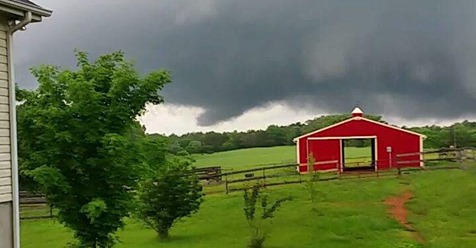
Video taken by an eyewitness showed a roiling cone-shaped cloud above the treeline, which appeared to briefly connect with the ground twice.
The National Weather Service office in Blacksburg was calling it a “probable tornado” until it can conduct a track survey and gather more details on Monday.
There were also two reports of trees down in neighboring Appomattox County, but without further tornado sightings.
The cluster of thunderstorms that moved over that area appeared disorganized, and no warning was in effect at the time.
According to Doppler radar, which detects the speed of raindrops within a storm, a weak but persistent whirl of rotation crossed over the areas that reported damage.
Campbell last saw a tornado on April 15, 2018. That tornado, which began in the Timberlake area, reached EF-3 strength and injured a dozen people after it crossed Lynchburg and entered Amherst County.
***
At 6:52 p.m., the next tornado touched down just north of downtown Suffolk, where it damaged at least 14 homes and six businesses near Constance Road. The tornado headed east and dissipated over the Great Dismal Swamp.
On Sunday, after completing a damage survey, the National Weather Service in Wakefield said the path was 2 miles long and up to 200 yards wide.
Ripped shingles, blown-in windows and snapped trees suggested winds of 85 to 90 mph, which rated it an EF-1 on the Enhanced Fujita Scale.
The parent thunderstorm blew in from Southampton County, where a severe thunderstorm warning had been in effect.
Rotation on its southern flank rapidly tightened up right as it crossed over Suffolk, and a tornado warning went out for the area at 6:51 p.m.
Tornado warnings continued into Chesapeake, Portsmouth, Norfolk and Virginia Beach as the storm moved east, though there were no additional reports of damage.
Suffolk’s most recent tornado hit on March 31, 2017, but it avoided populated areas.
***
These were the only tornadoes reported in the U.S. on Saturday, though there were dozens of instances of thunderstorm wind damage scattered between Louisiana and North Carolina.
Saturday’s severe weather outlook from the Storm Prediction Center did not include Virginia in any elevated risk category, and just depicted a general chance for thunderstorms over the region.
A stationary front was draped from west to east across Virginia, roughly along the U.S. 460 corridor.
As a result, wind directions were shifting in the atmosphere near the front, allowing the storms near the front to develop rotation.
Instability was very marginal, which limited the overall intensity of the storms. No severe weather occurred outside of those two isolated areas.
Across the state, Saturday’s rainfall ranged from less than 0.1 inch in spots to some small pockets that picked up nearly 2.5 inches.
A flash flood watch was posted for southeastern Virginia on Sunday in anticipation of more heavy rain during the evening.
by John Boyer (2019, May 12) Richmond Times-Dispatch