DETROIT, MI – The National Weather Service has now confirmed four tornadoes hit mid-Michigan during a storm that swept the state on Thursday, March 14.
The year’s first severe weather and tornado event did not result in any fatalities, but it did damage property in a wide-ranging area west of Flint.
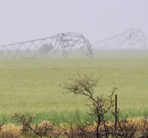
“A large, powerful low pressure system moved up across the central Plains, with weather ranging from blizzards to tornadoes,” the NWS reports. The first of two rounds of severe weather moved across the area as storms traveled at 100 mph, with winds about 40 to 50 mph at the surface.
The second round of severe weather, which is what brought the tornadoes to the area, was a line of thunderstorms that moved northeast just ahead of a cold front.
“As this line moved across the area, there were multiple areas of circulation embedded with the line which resulted in four tornado touchdowns across Shiawassee and Genesee counties,” the NWS reports. “Three out of the four tornadoes were weak and rated an EF-0. The tornado that hit near Vernon was rated an EF-2.”
Below is a breakdown on the four twisters:
Tornado 1 – SSW of Corunna, Shiawassee County
Summary: The tornado touched down close to the intersection of Bennington Greens Drive and Innsbrook Drive, snapping pine trees. The tornado continued northeast, crossing M-52 near West Grand River Road. Hardwood trees were observed snapped with large limbs down. The tornado then hit a Farm along South Morrice Road, just south of W Garrison Road. Trees were uprooted and a well built farm outbuilding lost its roof. The tornado snapped additional trees near Vandecarr and Bennington Roads before lifting near the Maple River.
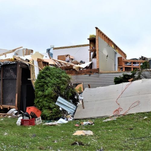
Tornado 2 – Vernon, Shiawassee County
Summary: The tornado touched down around the intersection of Britton Rd and I-69 and produced EF-0 damage up to Bancroft Road and Newburg Road with large tree limbs downed and trees snapped. Shoreline Lake Condos had over 10 trailers and mobile homes damaged from falling trees. The tornado continued northeast from Bancroft Road/Newburg Road to M-71 just ESE of Vernon producing EF-2 damage. One roof was completely taken off, a second story wall collapsed, and numerous homes with wall damage. The tornado weakened back down to EF-1 as two more home damaged near Bennington Road-Reed Road. The tornado finally lifted near Riniel Road just south of Lytle Rd.
Tornado 3 – Flushing, Genesee County
Summary: The tornado touched down on Nichols Rd just south of Corunna Road before traveling east/northeast to Calkins Road just east of Morrish Road. Damage included downed and snapped trees, large limbs, and a collapsed pole barn. The tornado lifted near Jennings Road just north of Pasadena Avenue.
Tornado 4 – Genesee Township, Genesee County
Summary: A tornado touched down near the intersection of Stanley and Bray roads and quickly tracked off to the northeast. The storm lifted near the M-57 and Irish Road intersection. The tornado was strongest when it hit the Camelot Villas off of Genesee Road. A mobile home was flipped onto its side, with another mobile home partially blown off the foundation. Roof and siding damage was prevalent within the mobile park. Clusters of trees were snapped and tree tops sheared along the tornado path, with a couple other small trailers flipped.
by Cole Waterman (2019, Mar 16) mLIVE