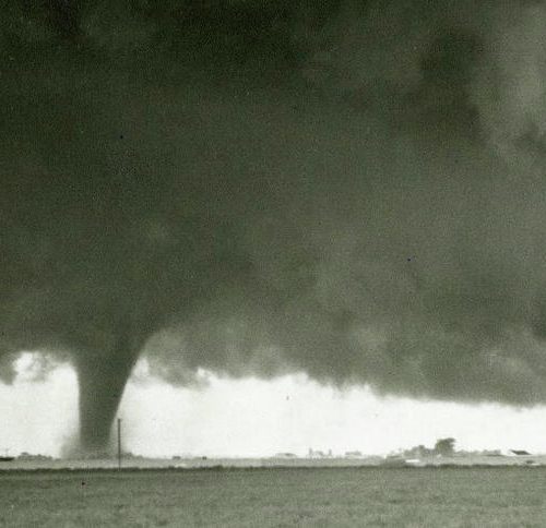
Tuesday’s very rare and strong December tornado in Washington state comes as scientists are learning more than ever about how tornadoes form and why they seem to be growing more powerful. One of those studies says your eyes are deceiving you — tornadoes do not drop down from the clouds. In fact, it’s likely the opposite, according to a new study presented at the American Geophysical Union conference.
Despite the thousands of scientists and storm chasers descending on Tornado Alley every spring, the exact mechanics on how tornadoes form is still not perfectly known. Even something as seemingly elementary as, does the funnel grow from ground or drop from the clouds, is still in debate.
For this research, Dr. Jana Houser and her team intercepted four tornadoes. They used a special mobile rapid-scanning Doppler radar, which returns data every 15-30 seconds, as opposed to every few minutes like more traditional land-based radars. Shooting a radar beam through the depth of the column, from cloud and ground, allows them to pinpoint where the rotation shows up first.
The most notable intercept was the infamous and deadly tornado that struck El Reno, Oklahoma, in May 2013. On that day a very large contingent of scientists and storm chasers were right in the storm’s path, providing an abundance of eyewitness as well as photographic, video and technological evidence. A more comprehensive analysis of how tornadoes form — what scientists call the tornadogenesis process — “has never before been obtained, providing a missing link in the story of tornado formation: the rotation associated with the tornado was clearly present at the surface first,” the researchers reported.
It turns out that in all four cases the team analyzed, none of the tornadoes formed from the top down. Either there was clear evidence the rotation was present near the ground first or the rotation took place simultaneously through the whole column.
Houser is quick to point out that the theory of tornadoes forming from the bottom up is not new. What is different in this case is that scientists now have the high resolution rapid scan data for support.
This is not to say that all tornadoes form from the ground up, but many do. Houser said, “While there are surely multiple ways you can get a tornado (we know this to be true already), I am confident that the top-down process is not what is actually happening in most situations.”
The fact that tornadoes forming from the bottom up is at odds with our visual perception is not lost on Houser. “I have seen multiple criticisms about this work based upon what people see with their eyes when they watch a funnel cloud,” she said.
It seems obvious: tornadoes look like they drop from the clouds. But this is an illusion. The reason is rather simple. Air is invisible. The only way you can see the spinning funnel is if the circulation is illuminated by dirt, debris or condensed water. Near the ground a tornado starts off with little, if any, dirt in its rotation. You can’t see it yet.
At the cloud base, moisture and humidity is condensed into visible cloud droplets; that’s why you see clouds. When a tornado forms it begins to cool and condense the humidity into visible cloud droplets further and further down the tornado funnel. Thus it appears like the tornado is moving downward. In reality the spinning funnel was already there — you just can’t see it until water droplets from above and dirt from below shrouds the tornado.
Dr Leigh Orf is a Tornado researcher and modeler at the University of Wisconsin-Madison. He generally agrees with Houser’s results. “Her findings are quite compelling; a visible condensation funnel intersecting the ground long before rotation was seen on research radars.” Orf adds, “I do not believe tornado vortices ‘snake downwards towards the ground from above’ — it is more likely that they form almost instantaneously along their length”
But even with all this high resolution data and research, fundamental mysteries remain, says Orf: “I would not say this observation in any way ‘solves’ tornadogenesis.”
In a video posted on YouTube, Orf uses stunning computer simulations to illustrate tornadoes in action.
Tornadoes and climate change
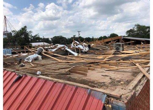
As the climate warms more mysteries arise. In a recent study published in EarthArXiv, an Open Science Framework website, Dr. James Elsner of Florida State University finds tornadoes are getting more powerful. And the increase in tornado power is significant: up 5.5 percent per year from 1994 to 2016. The finding is supported by storm reports which show an upward trend in the power of tornadoes from longer and wider paths and higher damage ratings.
Elsner and his team used a statistical model to derive tornado power while taking into consideration the daily 24-hour cycle, seasonality, natural climate variability, and the switch to a new damage scale in 2007.
In his paper Elsner notes the annual number of strong and violent tornadoes (rated EF2 or worse) has remained relatively consistent from year to year. However, the number of days with large outbreaks of many tornadoes is on the rise. An increase in the number of big tornado days means a larger threat of damaging tornadoes because the percentage of violent tornadoes (EF4 or worse) increases in those larger outbreak days.
Elsner theorizes this power increase is due to a combination of increased heat and humidity, termed Convective Available Potential Energy (CAPE), co-occurring with increases in wind shear. Wind shear is when winds change speed and/or direction with altitude. Generally more shear helps bolster tornadoes. Simply put, when heat, humidity and erratic upper level winds combine you get stronger tornadoes.
Since Elsner’s study is limited to only 22 years, CBS News asked him if this power increase could be due to known natural oscillations (cycles) in the Atlantic or Pacific Oceans or if climate change could be the culprit. Elsner said, “We cannot yet be sure if this is a long-term trend tied to climate change or a low frequency oscillation.”
Probing further, Elsner reveals that wind shear is increasing on days with many tornadoes, but not on days in general. So it seems that on any given day the propensity for tornado formation is not going up. But conditions on tornado days are riper than they used to be. In other words, extreme days are becoming more extreme.
Elsner thinks the more favorable conditions may be due to a “wavier” jet stream. The jet stream is the fast moving river of air in the middle and upper atmosphere which guides storm systems. The idea is that a rapidly warming Arctic, due to climate change, is causing less temperature contrast between the poles and mid-latitudes. This results in a slower jet stream certain times of the year, which is more likely to wander.
This wavy jet stream theory is a hot topic in climate change research as of the past few years. The concept of a jet stream that is wavier (undulates more) stems from work by Dr. Jennifer Francis in 2015. Since then there has been much research supporting this “wavy” jet stream concept.
As a climate expert, Francis is not a tornado dynamics expert but she sees how a wavy jet stream may lead to more powerful tornadoes. Francis said, “It makes sense that a wavier jet stream will bring more contrasting air masses in contact, which is one factor that may favor tornadic activity. Larger jet-stream waves may also mean longer periods of the ingredients that are favorable for tornado formation.”
There is one other piece of evidence that may help explain this uptick in tornado power. Since tornadoes form in environments that are laden with heat and humidity, a shift into a more humid zone would supply extra energy. That shift seems to be happening. A recent study, co-authored by Dr. Victor Gensini, showed a marked spreading of Tornado Alley from the drier U.S. Plains states into the more humid deep Southeast. This area has an open door to warm, moist air from the Gulf of Mexico, a body of water that has been getting warmer in recent decades.
Elsner said, “I do think that a shift of activity toward the southeast can explain some of the upward trend in power but that is not the entire story as we see an upward trend after statistically controlling for this shift.”
As Gensini told CBS News in October, “it’s not a big jump to say that climate change is causing this shift east. The hypothesis and computer simulations support what we are observing and what we expect in the future.”
Regardless of what is causing the surge in tornado power, assuming it continues, structures built in the tornado zones will need to be made less vulnerable to be able to withstand more force.
by Jeff Berardelli (2018, Dec 19) CBS News