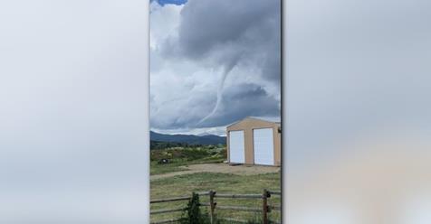
A funnel cloud in Steamboat Springs surprised a lot of people on Sunday who thought tornadoes and funnels can’t happen in the mountains.
They are rare at high elevations, but tornadoes can happen at any time and any place in Colorado. There have only been two confirmed tornadoes in Routt County since tornado record keeping began in 1950.
A long and narrow funnel cloud formed in a thunderstorm near Steamboat Springs at nearly 7,000 feet. Several reports, videos and pictures started coming into the 9NEWS weather center at about 10:15 Sunday morning.
There was no conclusive evidence that the vortex touched down on the ground, which would have made it a tornado. Often in Colorado, the very bottom of the tornado does not have any condensation in it, so the only way to tell if it is contacting the ground is to see a puff of debris like dust or dirt below it. So far no videos or pictures show that happening.
Sloped terrain and poorly organized thunderstorms make it difficult for tornadoes to exist in the mountains, but it’s wild mountain wind shear that really prevents them.
Tornado formation requires the winds to be gradually turning with height, the mountains disrupt this organized wind pattern into more of an inconsistent and crosswind pattern.
High Elevation tornadoes are usually weak, short-lived and are more likely in mountain valleys like South Park, the San Luis Valley, and even the Yampa Valley, but some tornadoes like the one that caused damage near Devil’s Head Campground in July of 2015 are on a steep slope. They have even been spotted on top of 14,000-foot peaks.
It should also be considered that high elevation tornadoes are just rarely seen. They may happen more often than we think, but visibility and sparse population prevents them from being seen. On the eastern plains of Colorado, tornadoes can sometimes be seen from more than 25 miles away. In the mountains, a tornado could be on the ground just over a ridge, but completely out of sight.
The National Weather Service in Grand Junction sent a meteorologist to Steamboat Monday to survey the area and conduct interviews. They will make a final call on whether it was a tornado or just a funnel and they will also try to determine the cause.
A supercell tornado can be ruled out, but there are a few ways a funnel like this can be formed. There is not very good data available from Doppler radar due to Steamboat’s distance from the radar stations. That area is at the furthest reaches of the radar sites in Grand Junction, Cheyenne, and Denver, and the mountains block a lot of the radar beams.
There is a possibility that it was a “cold core funnel”. Funnels can occur in thunderstorms in the cold sector of a mid-latitude cyclone. There was a moderate cold core environment over Colorado on Sunday.
A cold core environment exists when low pressure is vertically stacked from the surface to 500 Mb and is bounded by an area with a 700 Mb temperature equal to or colder than plus-1 C.
It is more likely that this was some type of shear funnel, which could be similar to an environment that creates a landspout tornado. There would have to be some vorticity on the ground or in the boundary layer, that got stretched into the thunderstorm.
It is even possible for wind shear off of the Park Range Mountains interacted with the downdraft of the thunderstorm to create enough speed and directional wind shear to create and sustain a funnel. Closer to a gustnado that forms along the gust front of a thunderstorm.
It might stay a mystery without enough data to support a conclusion, but at least the report from the National Weather Service in Grand Junction will soon provide the most details.
by Cory Reppenhagen (2018, June 25) KUSA