A severe storm moved through Monongalia county on Thursday, June 16th
from approximately 4:30pm to 5:30pm. During part of its lifetime it spawned
a weak tornado near the city of Westover at approximately 4:49pm.
Maximum sustained wind speeds were estimated to be 80mph. This
is classified as an EF-0 tornado (wind speeds ranging from 65mph to
85mph) and represents the lowest tornado intensity on the ‘Enhanced Fujita’
scale. The maximum path width of the tornado was 350 yards. Meaning
that an area of 0.20 miles long by 350 yards wide had evidence of
tornadic winds (circular, probably counter-clockwise damage). Thankfully,
no fatalities or injuries were reported.
The rest that follows is directly from the NWS Pittsburgh report on this storm:
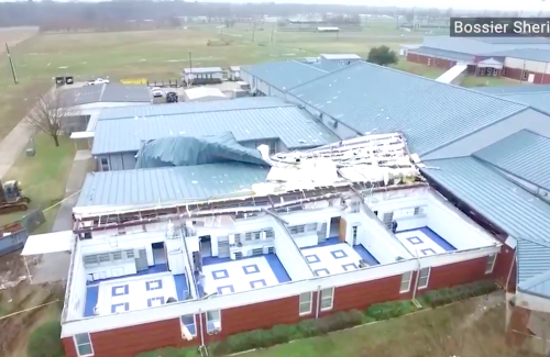
A weak tornado tracked west of Morgantown during the late
afternoon hours on Thursday June 16th. Mostly snapped and uprooted
hardwood trees were noted from the survey along Sierra Farm Road
west to Gallus Road. The winds blew out several windows of a
residence on Sierra Farm Road while stripping the roof of most of
its shingles. The last observed tornado in Monongalia county was
July of 2008 when a EF1 tornado moved across the southern part of
the county. This is the 7th reported tornado to affect Monongalia
County and 6th EF0 tornado since 1950.
More severe weather is possible through Thursday, June 23rd with large hail
and strong winds possible. A tornado cannot be ruled out either. We’ll continue
to track any storms that form through then.
Written by Ken Meehan
Last updated on June 20, 2016 @ 9:55PM
Created on June 20, 2016 @ 6:57PM
Photo: WDTV 5 NEWS