Tornadoes touched down across Western Europe on Friday, bringing scary scenes more typical of Kansas.
A damaging tornado hit Luxembourg while a menacing twister also sliced through Amsterdam.
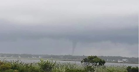
Watch the tornado shown in the video above as it tears across Amsterdam’s Oosterdok Basin Friday evening, frightening residents and tourists caught on or near the water as the funnel whirled precariously close. Views from the ground barely a hundred yards away show the tornado, which appears to be roughly 10 yards wide, furiously spinning counterclockwise as it crosses the small body of water.
No injuries or major damage was reported due to the Amsterdam funnel.
Though some are mistakenly calling it a landspout, this was a true tornado. That means the circulation started first within the clouds as a powerful supercell thunderstorm spun through.
It’s likely that the smooth surface of the water helped intensify the storm’s rotation enough to produce this tornado or strengthen it. It allowed a channel of inflow to speed into the funnel unimpeded, fueling the vortex. It’s interesting to note how quickly the funnel seems to dissipate or become more diffuse after crossing back onto land. Reports suggest the circulation was strongest over water, lending support to this theory.
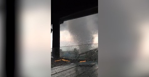
Other videos on social media depicted the tornado visible from skyscrapers and city buildings. Notice the funnel dangling from the cloud base does not appear to be connected to the debris at the ground. That often lulls people near a tornado into a false sense of security.
In reality, an invisible tornadic circulation can still cause damage at the ground even if the condensation funnel hasn’t fully become visible. Once the circulation moved near and over water, however, the additional moisture in the air made it appear rather quickly. Marked upward motion can be seen as well as the serpentine funnel looms ominously close.
Europe is not as popular for tornado touchdowns as the United States, but can see a flurry of activity each time an upper-level low swings in from the northwest. They probably see 200-400 a year. Italy and Greece are both hotspots for tornado activity, with supercells occasionally blossoming thanks to warm, Mediterranean air juxtaposed with unequal heating over the mountains.
Tornadoes in Western Europe are a bit more unusual, but can happen. An outbreak of tornadoes on Aug. 10, 2014, sent 16 twisters whirling through the U.K., France, Belgium, Germany and the Netherlands.
Seeing a tornado in Amsterdam is an impressive feat, considering the city lays at 52 degrees North latitude. For comparison, Seattle is only 47 degrees north. The Netherlands see many of their tornadoes later in the summertime, as farther north latitudes take longer to see summertime heat build in, and resultant contrasts develop, than regions to the south.
Additional tornadoes were reported in France on Friday, as well as Luxembourg. The latter struck in southwest Luxembourg near Pétange, where a weather station — probably fringed by the outer tornadic circulation or the storm’s downdraft — saw a wind gust to 79 mph.
Weather.com reported the storm caused major damage in Luxembourg, “where the mayor told the Luxembourg Times that roofs had been ripped off of about 100 homes.”
by Matthew Cappucci and Jason Samenow (2019, Aug 10) The Washington Post