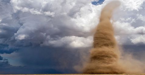
A once-in-a-lifetime tornado photo reached its 10th anniversary Tuesday, marking a powerful moment in extreme weather photography.
Photographer Jim Reed was hunting for severe weather to capture on May 8, 2008, in Colby, Kansas, when he came across the tornado that would be the subject of his legendary shot.
“I had a gut feeling it was going to be a good day and I would finally shoot a landspout tornado,” Reed wrote in an article for PetaPixel.
Following his intuition, he even prepared all his photography gear so he could get right into shooting, instead of setting it up two hours into the storm chase as he usually did.
“While shooting a few frames of the updraft base, I spotted a funnel and the prospects of a landspout tornado looked better and better by the second,” wrote Reed. “At 2:24 p.m. the funnel elongated toward the ground, so I called the National Weather Service (NWS) to report a possible developing tornado.
“Thirty seconds later, I spotted a swirling debris cloud on the ground three miles to our southeast—with only clear sky between it and the funnel,” he continued. “The vortex had yet to fill in with condensation or dirt, but debris meant a full-fledged tornado.”
Reed described it as “one of the most spectacular sights” he’s ever seen and opted to get even closer to the storm with his assistant, Robin.
“At 2:42, we jumped out, cameras firing. We were so close we could hear the tornado, which sounded like a rushing waterfall. Dust fell all around us,” wrote Reed.
The duo was snapping away when the twister began barreling toward them, forcing them to make a mad dash back to their vehicle.
“As soon as our doors were closed I reversed and slammed on the gas. To escape the tornado, I had to drive very fast backward, keeping us in the road’s grooves,” Reed wrote. “As I steered looking through the rear window, Robin described what she was seeing. ‘It’s getting closer and it’s growing—it’s coming towards us.’ The tornado was now chasing us down the road.”
Reed suspected the twister was losing steam and opted to stop the car and hop back out with the storm just 500 feet away. In a daring move, Reed ran toward the storm and captured the images that would go on to be iconic.
“Flying dust stopped me about 150 feet from the landspout. I fired off a few frames, but what I really wanted to do was stand there and take in the extraordinary interaction with nature,” he wrote.
“As the landspout dissolved, I slowly walked backwards toward the vehicle. I just didn’t feel it was respectful to turn my back on the vortex,” Reed continued. “Seconds later, the vortex collapsed, sending a tidal wave of dust over me. We were covered in it, but both cameras kept working perfectly.”
Even though they’re tornadoes, landspouts are different than twisters spawned from thunderstorms. They require a cumulus cloud to be present over a boundary of winds converging near the surface.
As that cumulus cloud grows and passes over the boundary, the rotating air is stretched vertically and eventually grows into a landspout. If you’ve ever seen a waterspout develop, it’s very similar, except landspouts occur over land.
The photogenic landspout captured by Reed formed in generally docile conditions, which allowed it to move slowly and into a tall tornado even though it was not connected to a spin in the clouds, according to weather.com meteorologist Jonathan Belles. They typically just spin up dirt or dust like this one did, but they can occasionally do some damage.
Reed and Robin’s photos from that day have been featured in books, magazines and even in a museum exhibit.
“I’ll always be grateful for that amazing assignment, to Robin for her shooting, and to nature for allowing me to get so close,” Reed concluded. “Happy 10th anniversary to everyone who played a part, and here’s to shooting the next adventure!”
by Ada Carr (2018, May 9) The Weather Channel