Two confirmed tornadoes touched down in the Midlands during a spate of severe weather Sunday, according to meteorologists at the National Weather Service station in Columbia.
Teams of surveyors headed out Monday morning to collect information on the tornadoes in Lexington and Irmo, as well as any other possible tornadoes that cropped up, meteorologist Jeff Linton said.
The first tornado touched down at about 2:15 p.m. in Lexington. Linton said it was classified as an EF0, with maximum wind speeds falling between 75 and 80 miles per hour.
The tornado in Irmo hit at about 2:17 p.m., and was slightly stronger, Linton said. The EF1 tornado had maximum wind speeds between 85 and 95 miles per hour.
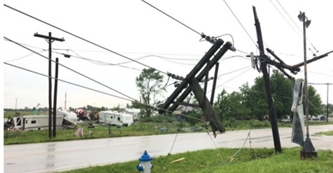
Storms raging across South Carolina on Sunday plunged thousands of homes into darkness, toppled trees and left more than a dozen homes damaged in the Columbia area.
A wind gust of 74 mph was detected at Columbia Metropolitan Airport around 2:20 p.m., the National Weather Service said in a tweet. A gauge on Broad River Road near St. Andrews Road registered a gust of nearly 60 mph, according to Richland County weather data.
At one point Sunday, SCE&G reported nearly 50,000 customers without power, and the S.C. Highway Patrol indicated nearly two dozen Midlands roadways with down trees or power lines.
Tornado warnings were issued in Lexington, Fairfield and Richland counties.
by Emily Bohatch and Teddy Kulmala (The State)
April 16, 2018