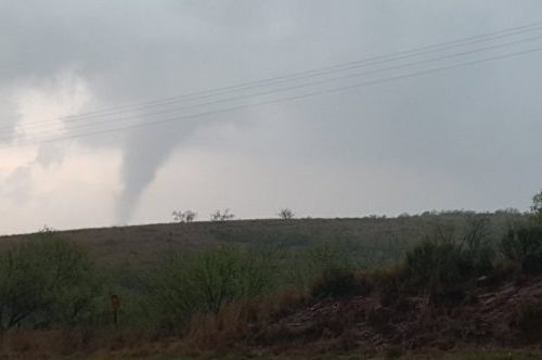
ALBANY — Baker, Dougherty, Worth, Turner and Wilcox counties were slammed Jan. 22 by an EF3 tornado that packed 150 mph winds and traveled nearly 71 miles in a northeast direction, starting several miles north of Newton and ending up near Abbeville in Wilcox County, leaving a swath that was, in places, a mile and a quarter wide.
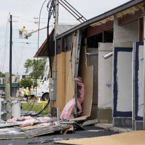
Five deaths in Dougherty County have been attributed to the massive cyclone, along with at least 40 injuries. Damages to homes and businesses are in the millions of dollars, and thousands are still without electricity a week later.
The preliminary results of the surveys by the National Weather Service — the numbers may be adjusted as more information comes in; for instance, the NWS does not yet list the fifth Albany death — show that the tornado touched down at the Red Store Crossroads north of Newton at 3:15 p.m. on Jan. 22. It ended 70.73 miles away — about two miles west of Abbeville in Wilcox County — an hour and 12 minutes later, meaning the whirlwind itself was traveling northeast at about 59 mph.
“In many spots, 90 to 100 percent of the trees in the path were uprooted or snapped,” a NWS report said. “In Dougherty County, the tornado touched down on Tarva Road.”
By the time it reached Albany, the tornado was about 1.25 miles wide and created extensive tree damage and some minor to moderate damage to a few homes. It “moved through the Radium Springs area, destroying nearly every tree in its path and causing EF2 damage to several houses. Most houses in this area had significant damage from falling trees,” the report says.
The tornado struck several mobile home parks just west of U.S. Highway 19, destroying mobile homes and causing the four fatalities. While not included in the report, a woman who was injured in that area died Thursday night, bringing the Albany total so far to five.
There was damage consistent with an EF3 tornado east of U.S. 19, and the giant twister “caused a large portion of a warehouse at the Procter & Gamble Plant to collapse,” while also tossing several semi-trailers across Mock Road. “Additional EF3 damage was observed at the Marine Corp Logistics Base, where multiple anchored double-wide trailers were completely destroyed,” the report says.
Some concrete light poles were snapped near the base and the solid concrete roof on an MCLB structure was shifted more than 2 inches. “A well-built concrete block church on Sylvester Road was demolished with only parts of a few walls remaining,” the report says. “The estimated wind speed at this point is 150 mph, the highest analyzed along the track. EF3 damage was also observed on Harris Road, where a cement block church was destroyed.”
The tornado entered Worth County, causing extensive damage to homes along Jewell Crowe Road, the report says, adding it was “consistent with EF3 damage.”
“Damage to homes and outbuildings consistent with EF2 damage was observed along Camp Osborn Road,” the NWS report says. “A concrete block church on Zion Church Road was completely destroyed, justifying an EF3 rating at that point.”
The tornado entered Turner County along and north of Son Story Road, with damage consistent at different points with EF3 and EF2 tornadoes. “There was also some evidence for multiple vortices near the intersection of Ireland Road and U.S. 41,” the report said, with EF3 damage observed on King Burgess Circle. The tornado continued northeast across Interstate 75, causing EF2 damage to several frame homes and mobile homes. Tree damage diminished as the tornado approached the Wilcox County line, suggesting that the tornado temporarily weakened,” the report said.
The tornado tracked through extreme southeast Crisp County and southwest Wilcox County, where it destroyed a small farm building and ripped metal trusses off another. Additional farm structures were severely damaged, and several large wooden electrical transmission towers were snapped. “Along American Legion Road, between Bayberry Lane and Elderberry Lane, a large (semi-truck) trailer was flipped, flattened and moved across a road,” the report said. “One (southeast) corner of a metal building structure was completely destroyed with 2-plus-foot (deep) concrete support beams ripped out of the ground. Numerous large trees were snapped near their bases around this location.”
NWS surveyors estimated the twister at EF2 strength with 110-120 winds at that point.
“The tornado crossed Highway 280, leveling numerous trees and destroying several small wooden sheds/barns,” the report said. “From this point, the tornado and parent supercell appeared to weaken considerably, with only some trees snapped or uprooted along Kingfisher Road, just west of Abbeville. No other damage was seen beyond Kingfisher and Harvey Road.”
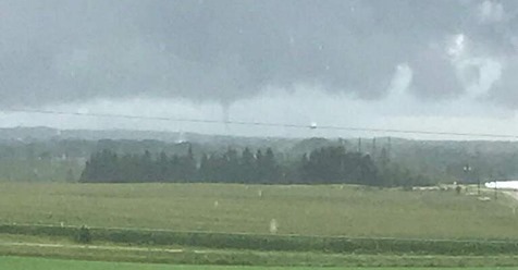
There were six other tornadoes reported with the storm system. Their details include:
— Brooks-Cook-Berrien Tornado: This was the deadliest of the tornadoes, causing 11 of the 16 deaths directly attributable to the high winds. With a peak wind speed of 140 mph, this EF3 cyclone was 700 yards wide at its maximum and traveled 24.88 miles. The tornado set down at 3:29 a.m. on Jan. 22 in Brooks County and lifted 29 minutes later two miles north of Allenville in Berrien County.
— Clay-Calhoun-Randolph Tornado: Rated EF2, this whirlwind packed maximum winds of 125 mph and had a maximum width of 400 yards. It traveled 12.07 miles after touching down in Clay County at 2:38 p.m. on Jan. 22. It lifted 14 minutes later in Randolph County. One injury and no fatalities were reported.
— Thomas-Brooks Tornado: Rated EF2, this tornado had a maximum wind speed of 120 mph and, at its widest, covered 700 yards. It traveled 18.74 miles after touching down at 2:56 a.m. on Jan. 22 in Thomas County. The twister lifted 22 minutes later in northwest Brooks County. There were three injuries and no fatalities reported.
— Lowndes County Tornado: Rated EF1, it had a peak wind speed of 100 mph and traveled 4.85 miles with a 400-yard path at its widest. It touched down at 7 a.m. Jan. 22 and lifted four minutes later. No fatalities or injuries were reported.
— Henry County Tornado: Rated EF1, this twister had a maximum wind speed of 110 mph and was 100 yards across — the size of a football field from goal line to goal line — at its widest point. It touched down at 2:14 p.m. on Jan. 22 and traveled 5.53 miles before lifting 12 minutes later. No deaths or injuries were reported.
— Franklin County Tornado: The only tornado in Florida was rated EF1 with peak wind speed of 101 mph. About 350 yards at its widest, it traveled 2.35 miles in four minutes after touching down at 2:50 p.m. EST. There were no injuries or deaths reported.
by Jim Hendricks
Jan 28, 2017 Updated Jan 28, 2017